Monday 31 May 2021

Pictures from a mostly damp week in Yorkshire.

17th to 22nd May 2021
 
First holiday of 2021, hopefully not the last.


 Embedding Flickr albums appears to be broken now so clicking on the image will take yo to my Flickr pages instead😞

Stoodley Pike

 
18th May 2021
 
My pre-booked leave coincided with the date the government let us go and stay away from home so I booked an Air BnB in Bolster Moor near Huddersfield in the hope of getting a little gentle hill walking in, weather permitting. In the event the Tuesday was the best day with the rest of the week descending into what can only be described as bloody wet. Lucky then that Tuesday was the day I picked for a walk up to the monument on Stoodley Pike, starting from and ending at the little car park at the Yorkshire Water facility by Withens Clough Reservoir.


The road up to the car park is narrow and rough, with enough potholes that I was a little surprised to meet a guy in an Aston Martin coming the other way. Not the ideal vehicle for that sort of road! There’s a height barrier at the car park entrance set at 6 feet, OK driving in but had to remember to duck walking out.
 
 Withens Clough Reservoir
 
The advantage of starting from Withens Clough is that the climb up to Stoodley Pike is less steep than from the north, following the Calderdale Way along the edge of the reservoir and then at the signpost turning right up onto the moorland with the sheep.
 
 Sheep near Withens Clough Reservoir
 
 At which point the weather turned Yorkshire enough to require putting on a waterproof coat before continuing upwards to a gate with a carved medieval stone marker nearby, the Te Deum Stone, this is a boundary stone or maybe coffin rest from when coffins were carried over packhorse trails from villages that did not have their own burial grounds. And I was able to look that up online as I passed because it also has a pretty good 4G signal!
 
 Boundary stone on the Caldedale Way near Withens Gate
 
Through the gate I turned right up a slightly steeper and rather squelchy path towards the top of the ridge, my first sight of Stoodley Pike monument, and some spectacular views down to Todmorden and Makinholes below.
 
 First view of Stoodley Pike
 
 Calderdale & Stoodley Pike (panorama).
 
After a brief sit down on a convenient rock to take photos I carried on along the ridge to the monument, meeting other humans for the first time on the walk, not many though, some walking their dogs and others just getting out onto the hills. I imagine that it can get crowded in the main holiday period, the paths worn into the ground between the rocks and bogs would seem to bear witness to its popularity.
 
 Stoodley Pike Monument. Made it.
 
It’s a big bit of stonework which being 1300 feet up affords great views and can be seen from a long way off. The 121ft tall structure here is a replacement, completed in 1856, of a monument built in 1815 to commemorate the defeat of Napoleon. That fell down in 1854 after decades of Yorkshire weather and then being struck by lightning. The inscription on the monument tells the tale:
 
A PEACE MONUMENT
ERECTED BY PUBLIC SUBSCRIPTION
COMMENCED IN 1814 TO COMMEMORATE
THE SURRENDER OF PARIS TO THE ALLIES
AND FINISHED AFTER THE BATTLE OF
WATERLOO WHEN PEACE WAS ESTABLISHED IN 1815.
BY A STRANGE COINCIDENCE
THE PIKE FELL ON THE DAY THE RUSSIAN
AMBASSADOR LEFT LONDON BEFORE THE
DECLARATION OF WAR WITH RUSSIA IN 1854.
WAS REBUILT WHEN PEACE WAS RESTORED IN
1856
RESTORED AND LIGHTNING CONDUCTOR FIXED
1889
 
The “war with Russia” mentioned is the Crimean War October 1853 to February 1856. 
 
 Stoodley Pike Monument.
 
Target achieved. Break out the flask of coffee.
 
 Coffee break, Stoodley Pike Monument.
 
 Having sat for a while watching the comings and goings of the people (mostly over the precipitous side of the hill facing Mankinholes) and passing the time of day with other walkers I planned a route back down to the car initially following the Pennine Way east then turning south along a marked path to the west of Sunderland Plantation woods. The threat of more rain appeared to have gone away and the sun was pleasantly warm but now the risk of getting wet was from the bottom upwards, the path following streams and across bogs where the way was only discernible by looking for the yellow-topped wooden posts marking the route. I wouldn’t have wanted to go that way in bad weather.
 
 Footpath? Marsh? Wall? All three in fact but which is which?.
 
There’s a path here, believe it or not! Or a wall. Or a stream. Or maybe all three. Yes, it is as deep as it looks.
 
 Stone gatepost above Withens Clough Reservoir.
 
Having managed to negotiate the swamp without falling in I stopped by this stone gatepost and checked the way back to Withens Clough Reservoir. Apart from the sheep and the birds it was very quiet with not a soul in sight. Unless sheep have souls of course and even if they do you can’t see them so why we use that phrase? Emerging back onto the track beside the water via a gate in the drystone wall (confirming that I was on the path I thought I was on) and realising that it was only just after two o’clock I decided it would be good to walk around the far side of the reservoir and back across the dam to the car park.
 
 View across Withens Clough Reservoir to Stoodley Pike.
 
 The Withens Clough reservoir was constructed by Morley Borough Corporation in the early 1890s and it served the town via a 20 mile pipeline and intermediate service reservoirs in the borough boundaries. The path on the far side is partly on a narrow raised bank with the reservoir lapping at on side and a deep water-filled ditch on the other. Inevitably I was going to meet someone coming the other way walking seven assorted dogs on leads. She certainly had her hands full and it was fortunate we passed at a point where the path was at its widest. Once around the reservoir is obviously a regular professional dog walkers route and when I next saw her in the car park she loaded them all into a van and scraped (literally) out under the height barrier making a noise to set your teeth on edge.
 
 Withens Clough Reservoir dam.
 
Withens Clough dam. Turn right at the far end back down to the car park.
 
It was a nice walk, moderately challenging, wouldn’t want to do it in bad weather though, such as any of the following three days.
 
Route statistics:
 
Distance walked 5.1 miles (8.2km).
Up 586m.
Down 596m.
Max height above sea level 411m
Total time 1 hr 48m excluding stopping, sitting, taking photos or drinking coffee.
Start/finish at Withens Clough Car Park, Rudd Lane 53.7058064N, 2.0214075W

Sunday 2 May 2021

May Day London


Q: Is it safe to come out yet?
A: I reckon so.
 
First time in the "Great Wen” this year due to you-know-what. Avoided travelling at the busiest times and got a coach to myself. Even so I was very glad to step outside Waterloo Station and de-mask. If you’d taken any notice of the media you’d believe that the streets are teeming with a mass of irresponsible “covidiots” but on the evidence of a Bank Holiday weekend Saturday afternoon walk I’d say that’s bollocks. Like much else in the papers and on TV. Here’s a few highlights.
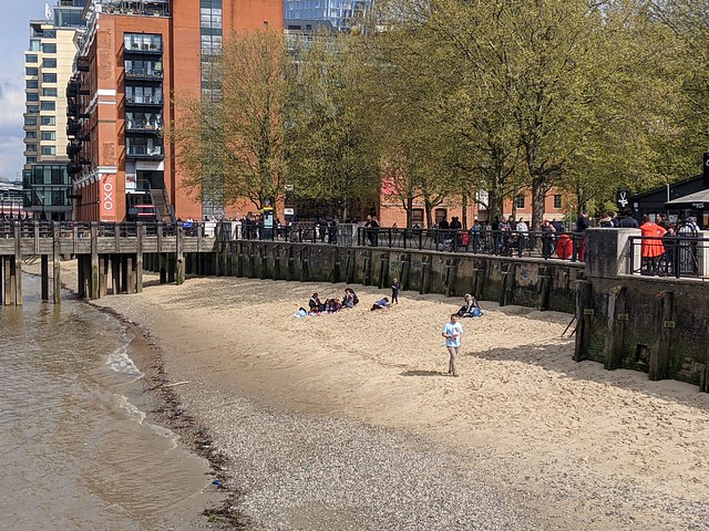
 
South Bank.
 
 The sun's out, go to the beach. "Dirty Beach" near Gabriel's Wharf.
 
Ok so hardly empty but for a Saturday afternoon hardly crowded either and easy enough to make you way along without bumping into anyone. As the sun was out some people just had to go to the beach :-)
 
 Clink Street.
 
I don’t think I’ve ever seen Clink Street this quiet either. Of course the museum is still shut and most of the overseas tourists are still overseas.
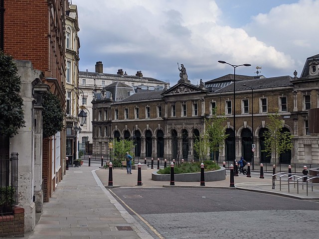
 
The City
 
The City of London is usually quieter at weekends but I don’t think I’ve ever managed to take a photo of Lower Thames Street without a motor vehicle in sight.
 
 Lower Thames Street, Old Billingsgate Market.
 
St Dunstan-in-the-East Built 1100, extended 1391, repaired 1631, damaged 1666, patched up 1668-1671, steeple added 1695-1701, rebuilt 1817, bombed out 1941, opened as a public garden 1971. A City of London history in one building. 
 
 St Dunstan-in-the-East.
 
A few picnickers, a few photographers. No shortage of places to sit down if you could find a bench that wasn’t covered in bird shit of course. In St. Mary at Hill I’d watched a grey squirrel brazenly running up the middle of the street.
 
 Seething Lane, tower of St. Olave Hart Street.
 
In Seething Lane, which wasn’t seething with people, the tower of St. Olave Hart Street was overshadowed by the surreal green reflection off the modern tower beyond. 
 
 St. Olave Hart Street
 
St. Olave’s is one of few medieval churches to survive the Great Fire of 1666, was rebuilt after being bombed in the blitz, and was described by Sir John Betjemen as "a country church in the world of Seething Lane”. Already overwhelmed by its surroundings it’s about to become even more so, planning proposal 19/01307/FULEIA having been approved for 

Demolition of 41-43 Mincing Lane. 40-54 Fenchurch Street, former church hall and the Clothworkers Hall and the redevelopment to provide a new building comprising four levels of basement (including a basement mezzanine level), ground, mezzanine, plus part 9, 31 and 35 storeys plus plant containing offices (81) and flexible shop/financial and professional services/cate and restaurant uses (A1/A2/A3) at ground floor level and flexible shop/cale and restaurant/drinking establishment uses (A1/A3/A4) ot levels 10 and 11. winter garden (Sui Generis): Reprovision of the Clothworkers on (Sui Generis) within part ground, part level): ) Creation of ground level public access to level 10 roof garden and basement level 1 to Grade ! Listed crypt ) Dismantling, relocation and reconstruction of the tombe's Chapel Crypt to basement level 1 and associated exhibition accommodation (Sui Generis) (listed Grade 1): v) Alterations to and conservation of the Grade 1 Listed Tower of All Hallows Staining: vi) Provision of new hard and soft landscaping and other associated works.

In order to enable the development it is proposed to stop up part of Dunster Court, part of Fenchurch Street, part of Mark Lane, part of Mincing lane and the whole of Star Alley. Big changes afoot here.
 
 Saint Edmund King and Martyr, Lombard Street EC3
 
In Lombard Street, hardly a soul about.
 
 Walbrook EC4.
 
Walbrook similar, although a private security guard strolled about giving suspicious looks at the photographer.
 
 Parish boundary markers, Great Trinity Lane EC4.
 
In Great Trinity Lane the churchwardens of St. James Garlick Hythe want you to be absolutely clear how far their bounds extend, though the building to which these markers are now attached wasn’t there in 1889 I think. According to this map  “HT” would be Holy Trinity the Less.
 
 College of Arms, Queen Victoria Street EC4
 
The College of Arms - the official heraldic authority for England, Wales, Northern Ireland and much of the Commonwealth, nothing to do with weapons - built in the late 17th century, sliced off in 1866 when Queen Victoria Street was built (from where this photo is taken), and narrowly escaping destruction during the Blitz in 1941saved only by a change in the direction of the wind. It’s about to get washed by a short, heavy rain shower. As did I.
 
 Faraday Buildings (BT), Queen Victoria Street EC4
 
Faraday Buildings, Queen Victoria Street. The GPO’s first telephone exchange in London, opened in March 1902. It obscures views of parts of St.Pauls Cathedral and led to the building regulations that protect views of St. Pauls from certain vantage points.
 
North Bank
 
 Moody River Thames from Victoria Embankment near Blackfriars Bridge.
 
Moody clouds over the Thames near Blackfriars Bridge. In spite of appearances the rain mostly held off, for which I was glad since “indoors” was still mostly out-of-bounds for virus reasons.
 
 Waterloo Bridge moment, the City Towers.
 
A “Waterloo Bridge moment”, looking downstream towards the city, the area I’d just walked through, before heading for sustenance at the Southbank Centre Food Market behind the Royal Festival Hall which had reopened the day before. Although Google thinks it’s still temporarily closed at the time of writing. Vegetable Biriani from The Indians Next-door  and very nice it was too.
 
All the above photos and more are in this Flickr album:
 
 May Day London 2021
 
And I’m looking forward to getting out more as restrictions are lifted.