Showing posts with label Essex. Show all posts

Wednesday, 17 September 2025

London Loop Section 24, Rainham to Purfleet.

15th September, 13:42 hours.

I finished my picnic lunch on the sheltered bench outside Rainham station and prepared for the final push along Section 24 to Purfleet. When I say prepared I mean tried to arrange my socks so that they didn't rub on my toes. I first crossed the Tilbury Loop railway line via the level crossing and then over the High Speed 1 line to the channel tunnel on a tall footbridge. Didn’t manage to time it for a photo of a Eurostar train but here’s the view looking towards the continent.

London Loop Section 24, channel tunnel that way.

Walking down the long ramp the other side I was hanging onto my hat in the blustery conditions, the yellow wind warning still very much in force. At the foot of the ramp I took the footpath along the north west edge of Rainham Marshes, then under the A13, crossing the slip roads using the light controlled crossings with very long wait times even when no traffic was coming, and back onto the narrow footpath around the edge of the marshes.

London Loop Section 24, Rainham Marshes.

I was momentarily thrown here as the route marked on Open Street Map follows Ferry Lane around the west side of the K9 Industrial Estate but this is wrong and I was on the correct path eventually crossing Coldharbour Lane and between the two industrial parks to reach the Thames at the point where there used to be a ferry across to Erith, founded in 1199 AD. If there was still a ferry it would link Section 24 here to the start of the LOOP, Section 1 across the water in Erith.

London Loop Section 24, River Thames at Rainham

I followed the path south towards the Tilda Rice factory, at a slightly lower level than the top of the river wall thus affording a bit of shelter from the wind but not from the first of the afternoon’s brief rain showers. The other side of the Tilda factory the path ran along the river bank and was much more exposed to the wind which was gusting strongly enough to make it hard to walk in a straight line. Not far along from the factory there are a number of World War 2 concrete barges, originally used to support the D-Day landings in Normandy they were placed here to shore up the Thames estuary flood defences after the damage caused by the storm and floods of 1953.

London Loop Section 24, WW2 Concrete Barges

Close to the barges a sculpture stands in the river, this is The Diver by John Kaufman The sculpture consists of galvanised steel bands on a steel frame and is a monument to Kaufman’s grandfather and to all the people of the area who worked in difficult and dangerous conditions. I’m sorry but I couldn’t help thinking of The WickerMan

London Loop Section 24, The Diver, by John Kaufman

From here the LOOP follows the river bank while on the landward side is the fence and high grass slope of the giant Rainham Landfill, in use for over a century and currently run by Veolia. At least the wind was coming from off the river so if it smells I couldn’t tell you. Along the fence are a number of painted wooden “grave markers” with humorous “obituaries” on them.

London Loop Section 24, Thames side "obituaries".

I passed the large jetty where clay to cap the landfill is brought in and reached Coldharbour Point where the Thames turned directly east so that from here on I’d have views down the river all the way to the Queen Elizabeth II Bridge and the docks at Purfleet.

London Loop Section 24, Coldharbour Point

At Coldharbour Point is located Momentum, a modern business and logistics park, surrounded on the landward side by the landfill and with the south side close to the river bank but with a high security fence and lots of CCTV. A number of pairs of wooden benches have been placed between the fence and the footpath, each bearing an engraved metal “No Smoking” sign. Just as well I gave up years ago although in that wind I doubt I’d have been able to roll a fag let alone get it to light! 😃

Instead I rested a while and finished the contents of my Thermos flask, there being no prohibition on Bovril. I carried on alongside the river with the occasional annoying shower that stopped as soon as you’d got your coat on 😒. I could almost see the end of my journey at Purfleet now.

London Loop Section 24, the Thames approaching Purfleet

Beyond the landfill I joined the path on top of the old river wall embankment that separates Aveley Bay on the river side from Rainham Marshes. I could have used the more sheltered path on the landward side but then I’d have missed the views. Including the Ro-Ro cargo ship Aveline passing quite close to the river bank on its way to Dagenham.

London Loop Section 24, Ro-Ro Cargo ship Adeline heading to Dagenham

Another short sharp shower got me as I approached the RSPB “Education & Environment Centre” and then I crossed the Mardyke into Purfleet.

London Loop Section 24, bridge over the Mardyke, Purfleet.

I walked through the riverside gardens past the Heritage and Military Centre located in a former Gunpowder Magazine to the point where a last LOOP sign directs you past the Royal Hotel to the London Road opposite the War Memorial.

London Loop Section 24, the Thames at Purfleet.

Unfortunately the hotel was closed, covered in scaffolding and builders, so no chance of a celebratory pint. I already knew it would be shut thanks to Diamond Geezer.

Instead I headed along London Road against the flow of secondary school pupils, half of whom were looking at their phones rather than where they were going, to the end of Section 24 and the end of the LOOP at Purfleet railway station. Is there anything to mark the end? Is there buggery. Not a footpath sign, not a LOOP information board, nothing to take a photograph of to mark the achievement. Also the kiosk outside the station was shut and I was thirsty so I just got on the next train to Fenchurch Street and had a celebratory pint in The Ship in Jews Row instead 🍻

London Loop Section 24, end at Purfleet Station (and the end of the LOOP)

London Outer Orbital Path - ✅

A Flickr Album from Section 24 is here.


 London LOOP Section 24

Tuesday, 16 September 2025

London Loop Section 23, Upminster Bridge to Rainham

15th September

I arrived at Upminster Bridge station on the District line at about ten past eleven in the morning which gave me plenty of time to complete sections 23 and 24 of the LOOP. First however a short diversion to Upminster Windmill, the actual mill this time rather than the pub as on my last visit at the end of Section 22.

London Loop Section 23, Upminster Windmill.

Upminster Windmill was built for James Nokes, a local farmer, in 1803. It is a Grade II* listed building and in terms of quality, completeness and significance it is widely considered to be amongst the very best remaining English smock mills, so called because its shape is said to resemble the traditional clothing of agricultural workers. It is owned by the London Borough of Havering and managed by the Friends of Upminster Windmill. It works and they have open days but today the slats on the sails were fixed open and the stiff breeze was turning the fantail that keeps them pointed into the wind. Talking of wind today there was a Yellow Warning for high winds and it was certainly very gusty.

From the windmill I returned to the route of the LOOP along residential streets, occasionally holding onto my hat. Once through Hornchurch Stadium’s car park the way ahead shadowed the River Ingrebourne, as it would for much of the remaining walk. Passing through an open grass area and then crossing the river on a footbridge to a stretch of scrub, woodland and rough grass with the unseen river now behind trees on my left. Across Hacton Lane and around the children’s play area I followed the well surfaced path through Ingrebourne Valley Local Nature Reserve, through shallow puddles until the route turned away to the right over a little wooden bridge provided to allow dry progress when the River Ingrebourne frequently breaks its banks at this point. As it had indeed today.

London Loop Section 23, Ingrebourne Valley Local Nature Reserve

Past another playground and a visitor centre and now I was entering Hornchurch Country Park, formerly RAF Hornchurch. Looking at the mostly wooded area that you pass through it’s hard to imagine that from 1928 until 1962 this was a military airfield, one that played a major part in the Battle of Britain being a Sector Airfield of RAF Fighter Command’s 11 Group, covering London and the south east of England and was attacked by the Luftwaffe on twenty occasions. It’s a lot quieter now but there are a number of leftovers dotted around from its wartime days, including several “pillbox” bunkers.

London Loop Section 23, pillbox,  Hornchurch Country Park (former RAF Hornchurch).

I passed Ingrebourne Marshes and climbed the slope up to where the control tower once stood, of which nothing remains but a good view to the south west.

London Loop Section 23, Hornchurch Country Park (former RAF Hornchurch).

The route carried on down the Ingrebourne Valley parallel to the river until turning west to skirt around Albyns Farm Lake and then south west again by Albyns Farm itself. This much restored and rebuilt medieval manor is surrounded by the sort of strikingly off-white high rendered wall that wouldn’t look out of place around a Spanish hacienda. Part way along which is a very large set of black wrought iron automatic gates with the name across them picked out in gold lettering and a CCTV entry system. It was probably the most Essex thing I saw all day (even if now technically in Greater London). I didn’t dare stand in front of the gates to take a photo though.

London Loop Section 23, Albyns Farm

Onward through field and wood to cross Ingrebourne Hill where I made the short diversion to the hilltop viewpoint. The path up to the viewpoint has been laid out in a series of lazy back and forth loops by some planner and which therefore mostly has a desire path cutting across them directly to the top because no one has time for that nonsense. There’s a good view from the top, particularly of towers, cranes, and the odd wind turbine across Dagenham, Becontree, and Romford. I returned to the LOOP via the other zig-zag path (mostly, see above) and beside Lake Stilwell to join the Rainham Road and turn south towards the village of Rainham itself. I passed the telephone exchange and its adjacent Albion pub, crossed New Road near the roundabout and then along Bridge Road over the River Ingrebourne again before nipping into Tesco for a pee because every little helps 😀

London Loop Section 23, Bridge Road, Rainham.

Then I carried on along Bridge Road following signs to the railway station which is the end of Section 23. I found a bench beside the station that was out of the increasingly strong wind and took a break for half an hour to eat my picnic lunch, (ham and cheese sarnies, crisps, a flask of Bovril, and some grapes that were a bit past their best if you’re curious) and prepared to tackle Section 24 to Purfleet. That will be covered in the next blog though.

London Loop Section 23, finish, Rainham Station

There’s the usual collection of photos from Section 23 in this FlickrAlbum.


 London LOOP Section 23


Monday, 8 January 2024

Walking from Roding Valley to Hainault

5th January 2024

This was the first day of 2024 on which there seemed to be a low risk of getting seriously wet. Wanting to relieve the winter cabin fever I took a long ride on the Piccadilly and Central Lines to a station I’d never been to before. It’s a station that most people haven’t been to either as Roding Valley is the least used tube station with only 259,271 entries and exits according to the latest official figures, 2022 at the time of writing. (Station Usage Data" (XLSX). Usage Statistics for London Stations, 2022. Transport for London. 4 October 2023.) So I’ve added 1 to whatever the 2023 figure turns out to be.
 
 Roding Valley, least used tube station.
 
 Served by the Central Line Woodford to Hainault shuttle there’s not a lot at Roding Valley station - not even a ticket barrier just Oyster/Contactless validators which must affect the accuracy of those entry and exit figures a little. I arrived from Woodford a little before half past midday a little disappointed not to have ridden on the newly refurbished train with its new moquette which is supposed to be running on the shuttle service. 
 
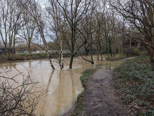
My “plan” was to take a short walk to either Grange Hill or Hainault and then head back into London again. I’d plotted a route on my phone which took me via Loughton Rugby Club, a short way along the River Roding under the Central Line to a bridge over the river and along Luxborough Lane to cross over the M11. Having crossed the edge of the rugby field I found that the Roding had other ideas.
 
 The River Roding in flood at the confluence of the Chigwell Brook.
 
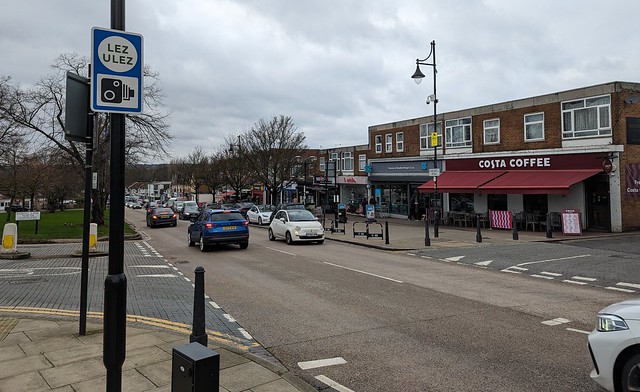
 There was about six or seven feet of the path flooded to “needs wellies” depth so I retraced my steps and found an alternative route via Ray Park, crossing over the river and under the M11 at Woodford Bridge, pausing for coffee at Costa on Chigwell Road. 
 
 ULEZ land, Woodford Bridge
 
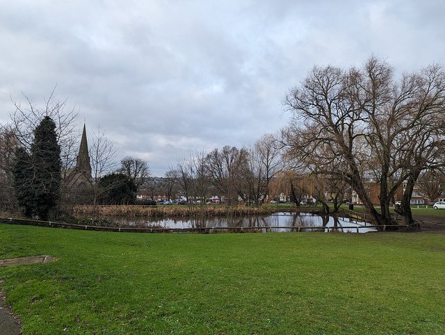
 Suitably caffeinated and having taken advantage of the other facilities I carried on past St. Paul’s Church and across the green by the pond then continued along Manor Road towards Grange Hill. A fairly busy road but with broad pavements and more importantly dry underfoot.
 
 Pond, Manor Road, Woodford Bridge
 
 Manor Road is peak Chigwell, isn’t it? Lined with very large detached properties behind big, often ornate gates mostly electrically powered. The front “gardens” nearly all paved over and accommodating a range of exotic or just large cars, many sporting personalised registration numbers (or twat-plates as I can’t help thinking of them). Visible alarm systems and CCTV adorn most of the houses. Every so often they’d got the builders in, refurbishing or extending the houses and blocking the footway with vans or skips. OK **** we’ll just walk in the busy road then shall we? Crossing the A23 the houses become more standard suburban fare and have suburban streets behind rather tan the golf course. On the opposite side of the road St. Winifred’s Church looks oddly utilitarian but is in parts at least older than it looks.
 
 St. Winifred's Church, Chigwell.
 
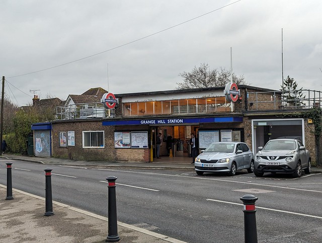
 I carried on along this less ostentatious part of Manor Road to Grange Hill Station. I could have got back on the Central Line here but Hainault is only a little further and I’d have needed to change trains there anyway. In fact the walk would have been shorter had I gone to Hainault directly but then I’d have missed the opportunity to make the obvious  low flying sausage joke
 
 Grange Hill Station
 
 So I passed by the station and turned down Long Green continuing along the alleyway at the end parallel to the railway. Rather unexpectedly there’s a World War II pillbox fortification here and a line of concrete tank obstacles along the edge of the line.
 
 WWII pillbox and tank obstables, Hainault.
 
 The alleyway emerges into Robina Close amongst blocks of flats and then via Clinton Crescent to New North Road where I turned right to Hainault Station entrance under the railway bridge.
 
 Hainault Stationentrance
 
 Hainault has some unusual tiled station name boards on the platforms which I thought reminiscent of a mid 20th century domestic fireplace particularly with the spaces intended for posters being mostly empty.
 
 Hainault Station tiled sign
 
 From the platforms the footbridge you can see the entrance to the Central Line Hainault Depot just north of the station. There are three platforms, one seems to be for the Woodford shuttle and the other two for trains towards London. Checking the next departures on both the TFL Go app and Google Maps showed completely different platform numbers to those actually being used so I followed everyone else onto the train at platform 3 that said it was bound for Ealing Broadway even though both apps said it was leaving from platform 1!
 
 Hainault Station
 
Roding valley ticked off I went to Gants Hill next but that’s another story. 


Monday, 8 April 2019

Estuary Escapade

5th April 2019

Thursday evening watching John Rogers on Youtube walking down the estuary coast through Leigh-on-Sea and Southend-on-Sea and thinking I have 4 days off work, what should I do? 

30 minutes later I've booked a night in the Premier Inn in Southend and a return railway ticket to Southend East. I've only been to Southend once, years ago for work and didn't see the seafront because I was booked into a hotel at the airport, a few miles inland. So I'd never been to the world's longest pleasure pier with its railway. Time to put that right.

The Journey

To get to Southend I chose to leave London from Fenchurch Street, arguably the capital's prettiest terminus. Another first for me.

Settled on board a late morning C2C train - no trouble getting a seat - and connected to the excellent free on-board Wi-Fi without having to part with excessive amounts of personal data. Other TOCs please take note.

For the first part the journey runs out through East London, then into the undulating and mostly flat Essex countryside. Between Leigh-on-Sea and Chalkwell the line runs right alongside the water, as close as does the GWR at Dawlish, and affords interesting views across the estuary. Arrived on time at Southend East station and walked down to the coast about three quarters of a mile through Southend's suburbs.

The Pier

First distant sight of the pier. Walked along the seafront to the pier and bought a return ticket for the pier train. 

Trains run from the shore end on the hour and half past the hour so I had a 20 minute wait. I thought I was getting the whole train to myself for a while ( I was visiting outside the busy season) but soon a gaggle of young Mums with pushchairs and pre-school age offspring joined the queue (at the front naturally).

There was only one of the two trains in use today but there was plenty of room - I made sure to be in a different carriage from the Mums & pushchairs. Although once electrified, train service is currently provided by two diesel trains, running on 3 ft (914 mm) narrow gauge track. Each train consists of a diesel-hydraulic locomotive at the southern end, five trailer coaches and, at the northern end, a driver control unit with passenger space. One train is named Sir John Betjeman, "the Pier is Southend, Southend is the Pier" , and the other Sir William Heygate.  I assume the latter refers to the local Baronets rather than Billy Butlin but I could be wrong.

A mile and a quarter of in places spectacularly bumpy train ride later the train arrives at the far end of the pier.

On the way it passes quite a bit of repair or building activity on the pier, getting ready for the summer season.

It was a fine if breezy day with the Kent shore on the other side of the estuary visible if a bit hazy and its a good spot to watch passing ships.


At the far end of the pier is the RNLI lifeboat station, museum, and shop on the bit that kinks to the east.

Between that and the railway station is a very modern building containing a cafe, with outside seating.

Tea and cake were consumed. The outside seating area is fairly sheltered and was pleasantly warm in the sunshine.

Unusually it was not necessary to defend one's cake from marauding seagulls. I don't recall seeing a single gull anywhere on the pier, and very few in Southend itself. Very strange. There were pigeons on the pier though they are much less trouble than gulls.

There was also a flock of birds sitting on a slipway on the east side near the cafe, all facing east. It would have been easy to walk past and not notice them, as I did the first time.

Apparently they're Ruddy Turnstones and have been something of an obstacle when it comes to carrying out any building or repair work on the pier.

They don't try to steal cake though.

Most of the other pier end attractions, mainly housed in wooden huts, were closed on this early season Friday so after taking lots of photos it was time for the return train trip and then go and check into the hotel.


The Seafront

Cannot be at the seaside on a Friday evening and not get fish and chips, can you? A little online research suggested that rather than the seafront fish and chip shops better was to be had by walking back up towards Southend East station and locating Brothers Fish Bar in Woodgrange Drive. The research was correct and the results excellent.

I took them back down to the front and enjoyed them there.

The tide had gone out and with it the earlier clear skies, the setting sun heavily veiled by clouds.

I walked eastwards along the seafront to Thorpe Bay past many small craft lying stranded on the mud by the receding tide, then up the long gentle slope through the straight streets of neat bungalows and past the shops and restaurants in The Broadway to Thorpe Bay station.

Where I was feeling lazy enough to get a train the two stops back to Southend Central in search of the bright lights.

I had thought there was more of Southend seafront than there actually is - it's no Great Yarmouth to be sure - but there were bright lights, a few bright young things, some rather odd "local characters" and The Borough Hotel which appeared to be the most pub-like bar on the seafront and the one most obviously serving real ale.

Pint of Fullers ESB, reasonably priced and perfectly acceptable. At least it wasn't the ubiquitous Doom Bar.

I had another and then a wander back up to the hotel, watched the latest from All The Stations Ireland on Youtube (Premier Inn free Wifi ✅) and slept like a log. It had been a long day.

Shoeburyness

The next morning I took a train to Shoeburyness. There's quite a lot of historic defences on the coast there though as it turned out mostly not accessible to the public as they're on MOD land.

The biggest and most obvious though is the northern end of the Anti-submarine Boom that went from here to Sheerness on the Kent coast.

Originally built to protect the Thames and London from Nazi U-boats the current structure dates from the Cold War.

There's really not a lot else at Shoeburyness. As the catering van on the beach was not yet open (at 1030) I grabbed a sandwich in the local shop and headed back to the station.

More Trains

The train back to Liverpool Street (Fenchurch Street not being served at weekends) had about half a dozen passengers on it leaving Shoeburyness but was standing-room only by the time it arrived in London.

For once the trains all ran OK and Paddington to reading was on a good old HST rather than the new IET, that won't be the case for long.

I even managed to get within 100 yards of home before the rain started!

So that was an enjoyable if brief excursion to Essex and I can now say I've visited Southend properly rather than just the motel at the airport which honestly really resembled that in Crossroads 😀

As ever there are more photos from this trip in this Flickr Album