Showing posts with label Gloucestershire. Show all posts

Saturday, 31 July 2021

The Source of the River Thames


Monday 26th July 2021

We’d got back our “freedom” and the rain had let up for the day at least according to the forecast. Time to pick a random destination and get back on the rails.
 
The source of the River Thames lies in a remote meadow near the village of Kemble in Gloucestershire - which used to be in Wiltshire. At least the official source is, some argue that it’s actually at Seven Springs about 11 miles further north at the source of the river Churn because that flows into the Thames and is further from its mouth. That would make it the longest river in the UK but must be wrong otherwise surely the river that runs through Reading,Oxford (yes, I know, Isis), and London wouldn’t be called the Thames and the rowing regatta would be held at Henley-on-Churn. Also the former TV channel would have been Churn Television although you could argue that would have been more apt.
 
Anyway the source in Trewsbury Mead has an official memorial stone and a signpost and all that so ignore the pedants. It’s also conveniently not too far from a railway station (Kemble) and a pub so that’s where I went to find the start of the longest river in England. No, the Severn is partly in Wales so you can delete the comment you were about to write.
 
 GWR Class 165 at Sandhurst
 
We now have a somewhat irregular service pattern on our railway line, introduced last year to go with the replacement trains that we haven’t got yet, which means that as far as I can make out the first off-peak service to Reading, to connect with the GWR main line, is at 1026. That would have got me to Kemble at 1140, plenty of time to walk to the source and then go and have a pub lunch. Unfortunately as well as being irregular the service is unreliable and that train was cancelled due to a points failure and the next was consequently about 20 minutes behind schedule arriving at Reading just in time to watch the 1153 to Kemble (the one an hour later than the one I should have been on) depart from platform 7. There is no 1253 train from Reading that stops at Kemble so I had to go to Swindon and wait for a train to Kemble that started there. Actual arrival at Kemble was 1341 a bit late for lunch (good job i’d bought a picnic on the way) but just qualifying for a 100% Delay Repay refund on my ticket. I’d have preferred to have been on time.
 
 Kemble Station showing the start of the abandoned Cirencester branch line to the right.
 
Kemble Station is small, with long platforms and a large water tower at one end of the down platform in traditional if faded GWR colours. Since this part of the line hasn’t been electrified it also still has its iron lattice footbridge linking the two platforms, not yet replaced in order to provide space for overhead wires such as has happened elsewhere. From the road bridge on the London side a spur of track can be seen leading off to the north. This is the remains of the Cirencester branch line, opened by the Cheltenham and Great Western Union Railway in 1841 and closed on 4th October 1965. This branch crossed the course of the River Thames north of Kemble at about where the A429 does now, making it then the highest/uppermost rail crossing on the river.
 
It’s about a mile and three quarters (2.8km) from Kemble Station to the source of the Thames, leaving the station north car park and turning left for a few yards then right onto a broad grass footpath and you are off the road for the rest of the walk except for crossing the A433.
 
© OpenStreetMapcontributors
 
A little way before getting to the A429 there’s a Thames Path sign pointing left over a wooden footbridge and shortly after you are following the River Thames. It might be a little difficult to spot unless there’s been a lot of rain though. On my visit it was visible only as a reed-filled ditch about 3 yards across.
 
 The River Thames, only a reed-filled ditch here.
 
Further along the path crosses a farm track which itself crosses the Thames on a sort of low bridge or culvert, so water must flow here in some quantity at times although it was bone dry today.
 
 The first "bridge" over the Thames, albeit very dry today.
 
The Thames Path rises to cross the A433 Tetbury to Cirencester road near where it crosses the Thames, which it the highest road crossing on the river although in contrast with the lowest crossing it requires neither bridge nor tunnel to do so, the river being small enough to be culverted so it’s hard to work out where the actual crossing is.
 
 At the A433, the highest road crossing the River Thames, or at least the course of it.
 
I followed the clearly marked path that climbed gently across the fields of Trewsbury Mead to the obscure corner the edge of the woods where the stone memorial and a pile of rocks in a shallow depression mark the official, accept-no-substitute Source Of The River Thames.
 
 The Official Source of the River Thames
 
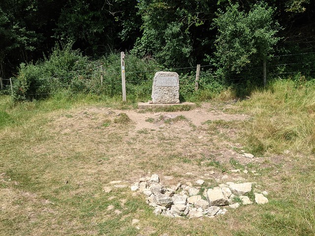
The inscription on the stone, unreadable due to wear and bright sunlight, reads
 
"The Conservators of the River Thames
1857 – 1974
This stone was placed here to mark the
Source of the River Thames".
 
Alongside the stone is the first (or last) Thames Path footpath sign, pointing the way down the 184 miles of the national trail to the barrier at Woolwich, which is definitely a lot noisier and busier than this end. I ate a solitary picnic against the only suitable tree that I could find to shelter under from the now quite hot sun, not even disturbed by the middle-aged couple walked down from the other direction, took their selfies, and returned the same way.
 
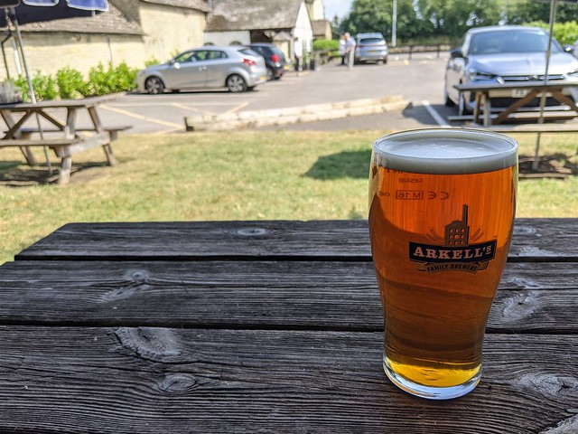
Then I returned along the Thames Path to the A433 and turned right along the road and under the railway to the Thames Head Inn. Because it would be rude not to really. It was the first time I’d set foot in a pub for over a year due to you-know-what but i remembered how it worked and enjoyed a nice pint of Hoperation IPA (ABV: 4.2%) sitting in the shade in the beer garden. I might have had another but had a train to catch from Kemble three quarters of a mile away down a country lane. A train which actually ran on time, as did the connection at Reading, making a better end to the day out than the beginning. 


 A welcome refreshment at The Thames Head Inn.

Sunday, 11 October 2020

Lydney

 Monday 7th September 2020

Lydney Harbour

Day three on holiday and I'm looking for local history. Nearby in Lydney the map shows an ancient monument, Lydney Harbour which as well as a harbour has a canal and disused railway. Out into the wet and windy morning I went.
Lydney Harbour tidal basin
The harbour at Lydney wasn't quite what I'd imagine a harbour to look like (if I hadn't already checked the map) being long and narrow and looking more like a lock.

It lies at the end of a 1 mile canal and gives access to the tidal River Severn. The gates of the tidal basin shown here appear to be stuck open so that it is filling up with silt from the river. They're spending a couple of million on the site to upgrade the tourist facilities (hence the digger and wire fencing) so hopefully that will include fixing the gates. Parking is currently free though after the refurbishment who knows.


Between the tidal basin and the canal is a lock and the canal serves as a marina for small craft.

A bit of history: The canal opened in 1813 and the outer harbour was completed in 1821. Coal and iron ore from the Forest of Dean was shipped out, brought down by a tramway which was in 1868 converted to a broad gauge railway although in 1872 that was converted to standard gauge. 
As can be seen from the early 20th century map below there were extensive sidings serving the harbour.

Reproduced with the permission of the National Library of Scotland

Lydney Harbour former railway
Parts of the track bed can be seen and walked along and there are markers pointing out wrecks on the river shore and "sighting stones" core drilled through pointing at distant landmarks.

Also a circle of standing stones, not ancient but dating from the refurbishment of the harbour around 2006 - apparently it works as a compass, something I failed to notice at the time.


I walked along the track bed on the west side of the
Lydney Harbour marina

inner harbour then crossed the swing bridge and back up the east side to the lock and harbour entrance.

There are a lot of boats moored here, I'm not sure if they can get out onto the Severn until the tide gate is repaired? The Environment Agency page doesn't mention it.

The last coal was shipped from the harbour in 1960 but imported wood was still being brought in by barge from Avonmouth. In 1977 the harbour closed and began to fall into disrepair, scheduled as an ancient monument in the 1980s with the swing bridge Grade II listed the harbour re-opened after a two-year project of restoration and enhancement in 2005.

Lydney Harbour lock
There are still a few old buildings around the lock and harbour and if you look closely on the west side the remains of the coal tip shown on the above map where coal was offloaded from the trains to the barges.

The old mortuary building was inaccessible due to the ongoing building works - I gather it's going to be made into public toilets which will be dead convenient. Sorry.

Crossing back over via the lock gates I went out to the rather windy harbour entrance where I could see up and down the Severn. 


Severn Bridges
On a clear day you'd get a really good view of the Severn road bridges downstream, this wasn't a clear day and with occasional showers as well but the bridges were just about visible anyway. The view of the Berkeley Nuclear Power Station on the far side of the river was much clearer.

A short but heavier shower sent me from my perch on a bollard on the harbour wall back to the car.

So Lydney Harbour was interesting with quite a bit to look out for, let's hope they don't spoil it.


Lydney Junction

I parked in the railway station car park so that I could walk into Lydney town centre, between the two
lies Lydney Junction station, the southern terminus of the Dean Forest Railway. Crossing over the tracks at the level crossing this very shiny Brush Type 2 diesel locomotive was hard to miss. Newly overhauled I think.

I'd have liked to take a ride on the DFR but when I tried to book for the Wednesday trip discovered that it was not possible to book only one ticket. No doubt trying to maximise their income under COVID-19 restrictions which I can sort of understand during the busy summer period but mid week after the schools had (finally) returned? I doubt that the train was going to be full. I note that this restriction remains in place even now in mid October. Alienating potential customers could be a policy that comes back to bite them in the arse.

Lydney Town

I can tell you that the walk from Lydney railway station to the town centre isn't very interesting, apart from trying to get across the A48 without being mown down by traffic at the roundabout. That the River Lyd near the boating lake smells quite unpleasant, although that might be the treatment works, and that on this particular post-lockdown Monday a lot of Lydney was still shut. At least it was some exercise.


Thursday, 8 October 2020

Escape to the Forest

 5th to 12th September 2020

It's been a month since I went on holiday, I should get around to writing about it.

Having spent most of my leave this year "staycationing" as the modern parlance has it, or more accurately sitting at home doing SFA because of you-know-what, I really wanted to get away for a week. Hotels seemed like too much faff so I decided to a holiday cottage, at least if everything went tits up and the lock-down returned I could do SFA with different scenery. Where to go in September? Hadn't been to the Forest of Dean in a long time. Ooh look, a converted water mill, that looks nice, clickety-click.

DAY ONE: Estimated journey time 2h 20m. Actual journey time 4h 30m. 

Just my luck to travel on the Saturday that the M4 was shut between J12 and J14. At least the cottage was
Old Corn Mill, Blakeney, Glos.
easy to find.

It was also comfortable and nicely equipped, far enough away from the main A48 through the village to not suffer from traffic noise but close enough to walk to the village shop (had I needed to), the pub (had I desired to), and the chippy (which I did).

Blakeney (the one in Gloucestershire not the one in Norfolk) is on the edge of the Forest of Dean and close to the Severn estuary. It has no railway station (not any more and when it did it was goods only) although the nearby town of Lydney does which is a short drive away. It's a good place from which to explore the border country which is why I came.
An evening walk towards the Severn along the lane and along footpaths that were in places not exactly made obvious across the fields.

Far reaching views across the Severn from Purton on the west bank to the other Purton on the east bank.

Down through the woods passing only a farmer walking in the fields (I assume - she looked like a farmer anyway), almost to the water's edge. 

Except not quite. For along the riverbank runs the Gloucester to Swansea railway line.

At least this driver sounded his horn with enough time for me to whip the phone out and get a photo as the train passed by next to the footpath. No, I don't write down the numbers.

From the waterside at Gatcombe up through the woods and along narrow lanes then a path cutting across the fields in the last of the daylight, startling a woman walking three dogs who didn't expect to see anyone else here, or so she said.


Then a choice, footpath around the water treatment works or along the unofficial but clearly well trodden disused railway back to the lane a mere hundred yards from the cottage.

A win for the former Forest of Dean Central Railway track bed. And to another bed.


to be continued...