Showing posts with label travel. Show all posts

Tuesday, 20 October 2026

A Day Trip to Banbury Cross

19th October

A dozen things from a visit to Banbury.

1: Three trains, zero Cock Horses.

387151 at Didcot Parkway

2: A Medieval cross which is really Victorian. In the Middle Ages three crosses stood in different locations around the town. All three, The White Cross in West Bar, The Bread Cross near Butchers Row and High Street and finally The High or Market Cross in Cornhill were all destroyed by puritans at the start of the 1600’s. The puritans disliked religious imagery and the superstitions associated with it.There are no remains of these crosses visible today but plaques mark their likely locations. The current Cross which was erected in 1859 to celebrate the marriage of Princess Victoria, eldest daughter of Queen Victoria to Prince Frederic of Prussia, reaches a height of 16 metres. The carvings on the lower section of the cross display the arms of the Town at different times and include the Town’s motto ‘Dominus nobis sol et scutum’ - which translates into ’God our sun and shield. The statues of Queen Victoria, Edward VII and George V were added in 1914 to mark the coronation of George V. On the upper sections are coats of arms or people who have a strong connection with the town. 

(Information above taken from an explanatory sign in the street nearby.)

Banbury Cross

3: A Fine Lady Upon A White Horse, but only a statue. This statue was funded and erected by the people of Banbury to commemorate the nursery rhyme which has made Banbury famous throughout the English speaking world:

RIDE A COCK HORSE TO BANBURY CROSS TO SEE A FINE LADY UPON A WHITE HORSE WITH RINGS ON HER FINGERS AND BELLS ON HER TOES SHE SHALL HAVE MUSIC WHEREVER SHE GOES

This rhyme contains three essential elements: Banbury Cross, the ‘Cock Horse’ and a Fine Lady upon a White Horse. One explanation of the ‘cock horse’ is the children’s hobby horse and Banbury holds a Hobby Horse Festival in the first weekend of July each year, with a parade of hobby horse beasts’ through the town and Hobby Horse Races held in People’s Park. The statue of the Fine Lady upon a White Horse now brings the rhyme to life all year round. The statue was designed by Artcycle Ltd, cast in bronze and mounted on a plinth of local Hornton stone. The horse, which was sculpted by Denise Jutton is modelled on a Welsh Cob. The Fine Lady is depicted as the ’Queen of the May and incorporates many symbols of spring. 

(Information above taken from an explanatory sign in the street nearby.)

A fine lady on a white horse.

4: Large Ironstone fronted Whately Hall Hotel glowing in the sunshine in Horse Fair.A 17th century building but restored in 1949.

Horse Fair, Banbury

5: People’s Park with the town’s War Memorial.

People's Park, Banbury.

6: Budgerigars and Cockatiels in the 1992 Jubilee Aviary. The aviary in People’s Park was rebuilt for Queen Elizabeth II’s Ruby Jubilee, the 40th anniversary of her accession.

1992 Jubilee Aviary, People's Park, Banbury.

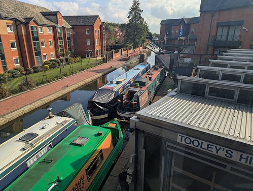
7: The Oxford Canal running through the town centre between the Premier Inn and the usual chain restaurants, overshadowed by the huge Castle Quay Shopping Centre but also with the oldest working dry dock in Britain. Tooley’s Boatyard, now a schedule ancient monument, has been building and repairing narrowboats since 1790.

Castle Quay, Oxford Canal, Banbury

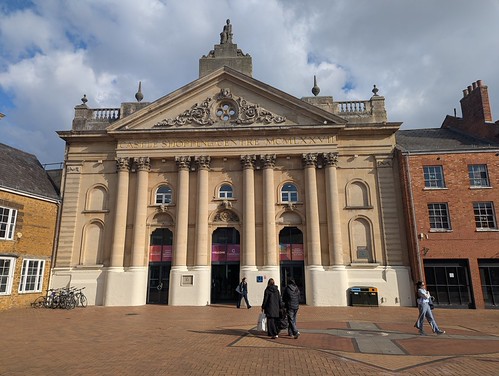
8: Former Cornhill Corn Exchange facade making a most impressive entrance into the Castle Quay Shopping Centre from Market Place.

Castle Quay shopping centre entrance, Market Place, Banbury

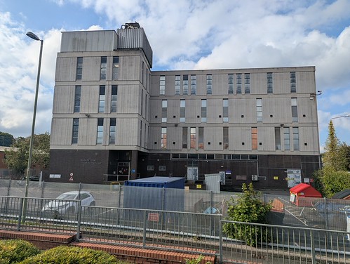
9: A Brutalist Telephone Exchange (one which I’ve never been inside) named after the Cross rather than the town.

Banbury Cross Telephone Exchange

10: A building in Bridge Street with well maintained “ghost Signs”.

Ghost signs, Bridge Street, Banbury

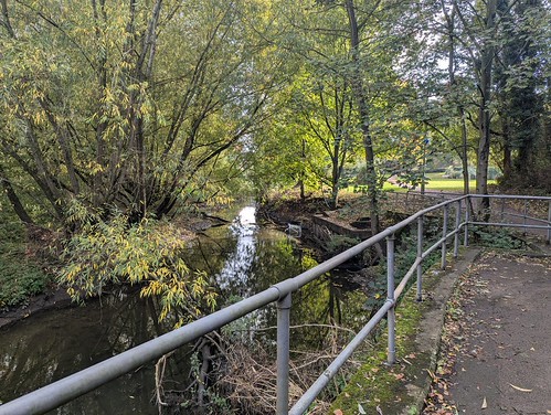
11: The River Cherwell, not pronounced how you’d think, with not much water, quite a lot of vegetation, and of course the obligatory shopping trolley.

River Cherwell, Bridge Street Park, Banbury

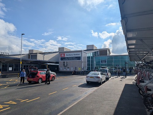
12: A very clean railway station, rebuilt in 1958 and made smaller in 2016, from which to catch the first of my three trains home.

Banbury Railway Station

13: 41 photos from a Banbury day trip in a Flickr Album.

 Day trip to Banbury Cross


Wednesday, 22 April 2026

A day trip to Lewes, East Sussex.

21st April

Pick a town, get a train, see what’s there.

Lewes (/ˈluːɪs/) is the county town of East Sussex and lies at the point where the River Ouse cuts through the South Downs. It is at a junction on the East Coastway railway line with lines to Brighton, Newhaven and Eastbourne and importantly in my case from London via Gatwick Airport, to which I can get a direct train. It’s also much more hilly than I’d appreciated from the map.

I arrived at Lewes’ triangular station at 1 p.m. on an afternoon which had become colder and cloudier than when I left home that morning.

Lewes Railway Station

I first headed south to the site of Lewes Priory, The Priory of St. Pancras to give it its full title. I had a picnic lunch and the hope that the sun might re-emerge. It didn’t but there was a bench in a relatively sheltered spot overlooking the ruins. In 1845, the Brighton, Lewes and Hastings Railway drove their new line through the middle of the priory site, including the priory church. The part to the north is privately owned but the part to the south is a public park, free to enter, and contains several monastic ruined buildings. Fragments of the dorter (monks’ dormitory), reredorter (monks’ khazi), frater (monks’ dining room) and infirmary can be see and walked around, or in the case of the only other visitor present sat behind with a small bottle of whisky.

Lewes Priory

With the dissolution of the monasteries under Henry VIII the King’s secretary Thomas Cromwell appointed a specialist demolition team led by an Italian engineer Giovanni Portinari to destroy the priory and they did a pretty thorough job. The manor of Southover which contained the priory was subsequently granted to Thomas Cromwell (now there’s a surprise) who built a large house on the site of the prior’s lodgings. After Cromwell’s falling out with Henry and subsequently being shortened by a head (see Hilary Mantel’s Wolf Hall novels and the TV series based on them) the manor passed through several hands until passing to the Sackvilles, the Earls of Dorset.

I left the priory site through the western exit having passed the medieval style Priory Tower folly and Priory Cottage which was built from stone taken from the ruins. I turned north up Cockshut Road (no sniggering at the back) alongside the priory precinct wall, under the very low arch beneath the railway to Southover High Street then east passing the Church of St. John the Baptist which was formerly the hospitium of the priory and which has a very fishy weather vane.

Cockshut Road, Lewes.

Turning left by The King’s Head I then ducked through an arch into Southover Grange Gardens to avoid the oncoming flock of primary school children being herded south. This was fortuitous since had I just continued along the street I’d have missed the pleasant gardens with the Winterbourne Stream running through in a straight channel and the best side of Southover Grange house itself. This house was built in 1572 by William Newton, using stone from the priory, and owned by this family for the next three hundred years. After this it was the residence of a series of wealthy merchants, bankers, and adventurers until it was sold by local gentleman farmer Harrie Stacey to the Council in about 1945. Now owned by East Sussex County Council it houses Lewes Registry Office.

Southover Grange, Lewes.

From behind Southover Grange I headed towards the High Street via St. Swithun’s Terrace and discovered how steep a hill Lewes is built on. I emerged onto the High Street from St. Swithun’s Lane a little out of breath. Lewes town centre is filled with interesting old buildings including the red brick Queen Anne - Baroque style Town Hall, an impressively grand Portland stone and bronze war memorial sited in the middle of a road junction, and a brick and stone Market Tower which also used to be the town hall.

Lewes Town Hall & War Memorial, High Street, Lewes.

I looped around the back streets and alleyways crammed with listed buildings including the former Star Brewery and a round cottage which is the stump of a windmill and once owned by the writer Virginia Woolf. I returned to the High Street via the steep and narrow Pipe Passage. This runs past the site of a clay tobacco pipe kiln but it’s fenced off. Having circumnavigated the castle I headed there next.

Lewes Castle, the Barbican.

Tickets for Lewes Castle (£12) are bought in Barbican House Museum on the other side of Castle Gate. The museum staff then have to escort you across Castle Gate to operate the electronic lock on the gate to let you into the castle. A zigzagging set of steps leads ever upwards to the top of the steep-sided castle mound. Here you can look out over the site of the Battle of Lewes, fought on 14th May 1264 between Henry III and a bunch of rebellious Barons. This didn’t end well for the King but Simon de Montfort fared rather better, becoming in effect the “uncrowned King of England” for a year while holding Prince Edward hostage to ensure that Henry ruled as “advised” by the Barons. Casualty figures are apparently unknown but don’t appear to have included any of the rich bastards whose power struggles started the unpleasantness in the first place. Nothing changes.

On top of the mound sits the stone and flint Shell Keep.

Lewes Castle, Shell Keep.

Inside the Shell Keep narrow spiral staircases take you up through several floors to the rooftop. It’s a lot of stairs but the views from the top over the town far below and the surrounding country are worth it. From up here you can also see the castle’s other “motte”, Brack Mount, a small wooded mound located at the north end of the bailey behind the long Maltings building. Lewes is one of only two castles in England built with two mottes, the other being Lincoln Castle where I’ve also been.

Lewes Castle, Brack Mount from Shell Keep.

You've climbed a lot of stairs so take lots of photos, I did (see link below). I also had the place to myself, probably because it was a Tuesday afternoon in April. I met a few other visitors while I was coming down but no more than could be counted on your fingers.

Lewes Castle, view from the top of Shell Keep.

A path around the Gun Garden named after the captured Russian gun from the Crimean War that is in it leads to the Norman Gate of which only one wall survives and the later Barbican Gate. This has an even narrower wooden spiral staircase to the rooftop. Here you can see a set of Machicolations. Holes behind the protecting parapet through which defenders could from a position of safety drop rocks, turds, hot pitch, and rotting animal carcasses on people attacking the castle gate below. For some reason these are now fenced off behind a sturdy railing 😃

After leaving the castle I had a look around the museum in Barbican House which has the usual collections of artifacts from prehistoric through Roman to medieval times found in a small town museum, and some history of the Sussex Archaeological Society. All located in a Grade II* listed sixteenth century house of course because you can’t stretch out your arms without touching a listed building in Lewes town centre.

It was past three o’clock so I continued down the High Street via a coffee shop in a bakery and some interesting old shop fronts then onward to cross the River Ouse at Lewes Bridge.

River Ouse and Harvey's Brewery, Lewes.

At the end of Cliffe High Street I turned round. Next to the river off Cliffe High Street is Harvey’s Brewery, the oldest independent brewery in Sussex. A family business since 1790. More importantly across the other side of the street is the brewery tap, the John Harvey Tavern. Hmm. If I got a later train than I’d originally planned I could sit in the sun facing the river - albeit across a car park - and have a birthday pint. So I did, Dark Mild because Mild is a rarity in pubs these days.

Harvey's Dark Mild - Happy Birthday to me.

Then it was back to Lewes railway station for the ride home. With an hour hanging around the windy hell-hole that is Gatwick Airport Station because GWR cancelled one of the trains to Reading. Of course they did. They’ll probably try to wriggle out of the Delay Repay claim too.

Lewes is a good place for a day trip though.

72 photos from Lewes in a Flickr Album (opens in a new page)

Or as a slideshow below if your viewer supports it:


 Lewes


Friday, 30 May 2025

May road trip journal, part 7

Day 9, Castle Douglas to Stoney Middleton via Nostell Priory. 228 miles.

When I departed Castle Douglas after breakfast my ETA at my next overnight stopping point was before check in time so I looked for somewhere to visit on the way. Nostell Priory, a National Trust property in West Yorkshire fitted the bill and I might as well make use of my NT membership for something other than free parking at Runnymede. The A75 got me to Gretna where I joined the M6 into England. At Penrith I left the motorway and crossed the Pennines on the A66 until joining the A1(M) at Scotch Corner and leaving it at Pontefract to head south west to Nostell Priory.

Nostell Priory

Nostell Priory is a Palladian house in West Yorkshire, on the road to Doncaster from Wakefield. It dates from 1733 and was built for the Winn family on the site of a medieval priory. The Winns were socially upwardly mobile textile merchants and the house was intended, as with so many such buildings, to show off their wealth and status. That wealth didn’t always match their ambitions. Robert Adam was commissioned to design additional wings but only one was completed so the frontage of the house is very obviously asymmetrical. Adam added a double staircase to the front of the house, and designed buildings on the estate, including the stable block where you’ll find the toilets, cafes, gift shop etc. The house has impressive interiors, Adam ceilings, lots of Chippendale furniture, lots of paintings, the usual stately home stuff. For me the most notable item was a longcase clock, with an almost completely wooden internal mechanism, made by John Harrison in 1717.

Nostell Priory, John Harrison's Clock

John Harrison was born but half a mile from the house and his stepfather worked on the estate as a carpenter. He developed an early interest in clocks and followed his stepfather into the carpenters trade, hence the wooden clock mechanism. Later he would become famous for developing accurate seagoing timepieces to solve the problem of determining Longitude at sea. Despite successfully producing such clocks he never received all of the monetary reward that was due (although he did eventually become a very rich man) and was badly treated by the establishment, the “gentlemen scientists” of which were loathe to acknowledge that a carpenter’s son had succeeded where they had not. Generations of sailors however have good reason to hold John Harrison in high regard.

Nostell kept me occupied for a couple of hours but I had to move on. I stopped for fuel near Wakefield and headed down the M1 towards Sheffield. For some reason known only to itself the sat-nav decided to go the “wrong” way around Sheffield which meant sitting in miles of crawling traffic before finally escaping into the Derbyshire Dales.

I arrived at The Moon Inn, Stoney Middleton at well past five o’clock, checked in and put the kettle on for a much needed cuppa. This time I didn’t need to put the kettle on the floor to plug it in. It was a nice room up in the first floor roof space, accessed by an outside door at the rear of the pub.

Stoney Middleton, The Moon Inn.

I had intended going for a chippy tea but it wasn’t open so ate at the inn instead. After dinner I’d planned on going for a wander around Stoney Middleton but looking outside saw that it was actually pissing down. Summer had arrived. Of course I had left my coat in my room. Since I’d have got wet going to my room I decided a better plan involved another pint and wait for the rain to let up after which I no longer felt the urge to walk around a wet Derbyshire village so I retired early.

Day 10, Stoney Middleton to Home. 181 miles.

I treated myself to a last holiday full English breakfast then checked out of the inn and since it was a fine sunny morning took a brief turn around the village.

Stoney Middleton, The Nook.

It’s quite picturesque, lots of stone buildings including a church and a toll-gate cottage which is also the Fish and Chip shop with the disappointing opening hours. In a little garden nearby to the tollbar is a large circular blue plaque bearing the following text:

BOOT AND SHOEMAKERS’ STRIKE

1918-1920

In tribute to the women and men of Stoney Middleton and Eyam who were on strike for over two years and set up their own co-operative factory. They sought the reinstatement of sacked colleagues, shorter working hours, a war bonus and recognition of their trade union, the National Union of Boot and Shoe Operatives.

Their action inspired workers in other local industries to join unions, and paved the way for better wages and working conditions for later generations.

Good on ’em, I say.

It was time to go home. Once again I picked a route avoiding the M25 despite the sat-nav insisting that it would be a whole 8 minutes quicker. Except it wouldn’t, it never is. I got home mid afternoon, unpacked and started on the big pile of laundry. The cupboards & fridge were looking a bit sparsely populated so I got a Ruby Murray delivered, shopping could wait until tomorrow.

Epilogue.

I’ve gone through the photos and got the album down to only 290 items. You can see them on Flickr here.

I drove a total of around 1,584 miles.

Accommodation cost was £962.31

Did I have a good time? Yes.

Would I do it again? Also yes, or at least something similar. I’d like to explore more of Dumfries & Galloway. I might stretch the driving to cut out the first and last nights stop overs although it’s a long way.

Should you visit Kintyre? If you haven’t already you certainly should.

Did I see the Beatle? No, I’m told he doesn’t live there anyway so there was no danger of that happening.

Wednesday, 28 May 2025

May road trip journal, part 5.

Day 7, Last day in Kintyre

It being Sunday I decided on a day of relative idleness. After breakfast I drove over to Machrihanish near Campbeltown Airport which has two flights a day to and from Glasgow with Loganair. It takes 45 minutes (plus faffing around at airports obviously) so is much quicker than driving but so, so much more expensive at around seventy quid each way. A former RAF and US Navy/Marines base when it was called RAF Machrihanish. Because it was redeveloped in the 1960s to support United States and NATO operations in the Clyde area and wider Atlantic it has the longest public airport runway in Scotland at 3,049 m (10,003 ft), built to allow use by nuclear bombers such as the Avro Vulcan and other large aircraft. Also used for the storage and distribution of nuclear weapons and as a US Navy SEALs base it was certified as a potential emergency landing site for the Space Shuttle in the 1980s, which had it been needed would have been a sight to behold. Post Cold War the Yanks went home in 1995 and it became a civil airport. The MOD sold the site to the Machrihanish Airbase Community Company in 2012 for a quid and parts of the site are used for commercial purposes. That included a maker of offshore wind turbines until they went bust.

I wasn’t going to the airport anyway but passed it on the way to the beach. It’s a remarkably large area of flat land for this part of the world. Machrihanish has a remarkably long beach with a large golf course separating it from the airport.

Machrihanish Beach

I went for a walk along part of it and then headed towards Southend again in the car. From Southend I took the narrow winding Le’arside Road around the south east Kintyre coast to Campeltown, stopping at Feochaig to look out over the Firth of Clyde to the almost hemispherical island of Ailsa Craig.

Yachts in The Firth of Clyde from Feochaig

I stopped again at Kildalloig just east of Campbeltown and checked the tide times but there wasn’t enough time to walk out over the causeway to Davaar Island and get back again.

Davaar Island

After a quick stop in Campeltown to visit the Linda McCartney Memorial Garden, which was closed so I had to make do with a photo taken over the top of the railings.

Linda McCartney Memorial Gardens, Campbeltown

I returned to the cottage and took advantage of the fact that the other cottages were now empty so the broadband speed allowed me to catch up with Youtube.

In the next thrilling episode I bid Kintyre goodbye and start heading for home via Dumfries and Galloway.

Monday, 26 May 2025

May road trip journal, part 3

Day 4, Garlieston, Dumfries and Galloway to Kilchrist Castle, Kintyre, 241 miles.

To get from Garlieston to my holiday cottage in Kintyre required driving a long loop up through Ayrshire to cross the Clyde on the Erskine Bridge, up the west side of Loch Lomond, around the tops of Loch Long and Loch Fyne and south again via Inveraray and Lochgilphead to Tarbert and further south to Campbeltown. With traffic, a fuel stop, occasional pauses to stretch the legs and admire the scenery it took most of the day. Taking it at a fairly relaxed pace made for a quite pleasant journey through nice country. Final stop before reaching my destination was Tesco in Campbeltown to stock up on provisions for the next 4 days.

Late in the afternoon I arrived at Kilchrist Castle Cottages, about 10 minutes drive south of Campbeltown. The cottages are in a separate compound to the rear of the castle accessed down an unsurfaced track and set amongst open fields. The castle itself is a private residence so not open to the public and only glimpsed through the trees surrounding it. MacLeod cottage would be my home for the next few days, a wee detached single storey building with one bedroom, a sitting room with kitchenette, and a rather cramped shower room and toilet. All I’d need for a short stay and conveniently located to explore Kintyre. What was less convenient was finding the handwritten note next to a bottle of cheap plonk offered as an apology for the fridge not working and the suggestion that I could use a fridge in the laundry at the other end of the site. I’d really have appreciated knowing that before I arrived with 3 days worth of breakfast supplies and salad. Even a message in the morning would have allowed me to plan accordingly. Looking back at the previous reviews for the cottage later I saw that the non-working fridge had been reported to the owners by a previous renter in April so it’s not like it had just broken that day. At least the wine was red rather than white.

MacLeod Cottage, Kilchrist Castle Cottages,

Other than the fridge issue it was a nice place to stay and when the sun eventually went down proved to have quite a dark sky with many stars visible to the naked eye. Quite a treat for someone from the light polluted south of England.

Day 5, Mull of Kintyre Lighthouse and the southern end of the Kintyre peninsula.

I had scouted out a couple of places on the map to visit. First was Mull of Kintyre Lighthouse. There’s a car park about 1.3 miles from the lighthouse and then you can walk down the private access road to the clifftop lighthouse site with views all the way to Northern Ireland. Getting to that car park is an adventure in itself along about five miles of narrow single track roads with steep hills, tight bends, obstructive sheep, and terrific scenery. Eventually the road ends at a small parking area before a gate with a sign that says “End of Public Road Turn Here”. From here on you’re on foot. The tarmac service road heads steeply down almost the whole way to the lighthouse gate, with several hairpin bends and the lighthouse appearing and disappearing from view. It was a gloriously sunny, hot day and much less windy than I’d expected as I walked down the steep road, all the while with the vague feeling that I was going to regret this idea on the way back up!

Mull of Kintyre, the road down to the lighthouse.

The views down to the lighthouse and across to Rathlin Island are very picturesque and occasionally a fishing boat would pass trailing a white wake on the deep blue water. It took around half an hour to get to the bottom, or at least the gate to the lighthouse compound. Apparently you used to be able to get right to the lighthouse itself but these days the gate is firmly locked shut.

Mull of Kintyre Lighthouse

I had the place to myself too, at least until I got to the bottom when after about ten minutes I was joined by two Dutch motorcaravanners, an English guy, and their Good Doggos. We had a brief chat and I let them start their ascent while I chilled out for a while. When I could put it off no longer I began my slow way back up the hill. It was still warm and sunny and there’s no shelter to speak of anywhere on the road so I took it steady, counting out 100 paces and stopping for breath, taking a few minutes rest and a swig of water every 300 paces or so until suddenly I was back at the top, a bit warm but not completely knackered. It took about twice as long to get up as it did to go down.

Off the road up on the hillside is a memorial for the RAF Chinook helicopter crash in 1994 which claimed the lives of all 25 passengers and 4 crew and spawned a few conspiracy theories since the passengers were all from the security services. There was also some controversy over the findings of the air accident inquiry, an RAF board of inquiry ruled that it was impossible to establish the exact cause of the accident but this ruling was overturned by two senior reviewing officers, who stated that the pilots were guilty of gross negligence for flying too fast and too low in thick fog. A later Parliamentary inquiry found the previous verdict of gross negligence on the part of the crew to be ‘unjustified’. In 2011, an independent review of the crash cleared the crew of negligence and accepted that the RAF had falsely declared compliance with regulations in relation to the aircraft’s authority to fly.

Mull of Kintyre, helicopter crash memorial.

By complete coincidence when I arrived back at the car I fell into conversation with the occupant of a motorhome which had just parked in the car park who turned out to be an 80 year old former RAF helicopter pilot. Interesting chap with an informed insider’s opinion of the incident described above.

I returned along the road to the lighthouse, inevitably meeting a fuel tanker on the way at an inconvenient spot, and headed for the end of the Kintyre peninsula, the appropriately named Southend but without a long pier. I pulled into a car park by the beach at Carskey Bay and walked the short distance to Keil Caves, St. Columba’s Footsteps, St. Columba’s Well, and his church ruins. The footprints are carved into the top of a rocky outcrop, one parallel to the shore and the other at 90 degrees to it with the year 564 also incised into the rock. The history is a bit confused but likely one footprint dates from the 4th century and became associated with St. Columba who landed here briefly in 563. The second was probably added by a 19th century local mason called Daniel McIlreavie to boost the area’s association with the saint and he also added the (wrong) date.

St. Columba's Footprints

Around 50 yards away St. Columba’s Well, a rocky bowl carved into the sloping hillside which collects not-entirely-wholesome looking water from a spring. This too may have obtained its association with the saint by way of 19th century tourism. Completing the St. Columba trio is the ruined church set along the landward side of a roughly rectangular graveyard and almost entirely overgrown so that from the footsteps it appears to be just a bunch of small trees.

St. Columba's Church (ruins) and graveyard.

The history of the caves is a little more matter of fact. Some have names such as the Great Cave, the Piper’s Cave - after the legend of a disappearing homeward bound piper who allegedly haunts the cave, and the Hermit’s Retreat. The caves were occupied on and off since prehistoric times until the late 19th century where the 1881 census records six members of the McFee and McCallum families as residents. If you enter the larger caves today you’ll find that the only residents are panicky pigeons.

Keil Caves

From Keil I took the coast road to Southend and then the B842 back to Kilchrist for tea, dinner, and the Friday night Top Of The Pops re-runs on BBC4 with accompanying commentary on Mastodon.

Next time I go to Campbeltown, explore the east side of Kintyre, and find an unexpected castle.

Saturday, 24 May 2025

May road trip journal, part 1

Where to? 

I wanted to visit a bit of Western Scotland I’d never previously been to, Kintyre, the long strip of Argyll & Bute that separates the Firth of Clyde from the Atlantic Ocean. It isn’t blessed with a lot of public transport options, no railways, you can get to the main town of Campeltown by bus and there are a few limited local bus services once you’re there. So practically I was going to need to take the car and it’s a long way from home - about 562 miles in fact. I know some people would happily do that in one go. I’m not one of them, 5-6 hours driving is quite enough else it becomes un-enjoyable and this was intended to be a relaxing holiday. So I broke the trip up into sections and booked accommodation at convenient points which also meant not just pounding up motorways all day.

Day one, Home to Laneshaw Bridge, Lancs. 244 miles. 

I plotted a route that avoided both London and the M25, and Birmingham and the M6, instead heading towards Oxford then Northampton before going north towards Sheffield and Leeds and then north-west across country to Laneshaw Bridge (or Laneshawbridge on some signs) in the Borough of Pendle. The weather was warm and sunny, which is unusual for any time I decide to take a trip, and the journey easy until the last few miles where the closure of a local road near Stanbury resulted in the sat-nav becoming unhelpful and eventually finding a way through that involved driving over the very narrow road on the top of the Ponden Reservoir dam. I’m still not sure that was the official diversion route or whether there even was an official diversion route. Signs? What signs? Once I’d passed that obstacle finding my way to the Alma Inn at Laneshaw Bridge where I’d booked a one night stay was a comparative doddle.

 The Alma Inn, Laneshaw Bridge

The Alma Inn sits on a hill above the village, surrounded mostly by fields and sheep. The room was comfortable with a nice rural view. The food was good, the beer was good, the decor in the bar and restaurant very much in the modern corporate pub style so almost entirely devoid of any atmosphere, and the free Wi-Fi was free in the sense of requiring all your personal and device data, presumably to sell on to third parties (there’s no other reason they’d need it) so it was good that there was 4G data coverage. After dinner I decided to have a little stroll in the evening sunshine, which turned into a slightly longer stroll down to the village and then up alongside High Laith Beck and across the fields back to the inn. I slept well after that.

 Lambs, Laneshaw Bridge

 Top tip: Don’t park under the tree in the inn’s car park, it drops sticky sap all over your car which is a bugger to remove.
In part 2 I get to South West Scotland.


Monday, 22 April 2024

Pilning (and Bristol)

April 13th

It seems to have stopped raining for the moment, time for a spring weekend getaway. I’ve not been to Bristol since 2020 before the you-know-what so I bought a small handful of rail tickets on Trainsplit and booked a couple of nights in a city centre hotel because I enjoyed Bristol last time and it’s easy to get to. I also had a little mission nearby that I wanted to do.
 
An emergency track repair on the GWR main line meant a delayed arrival at Bristol Temple Meads but I still had time to go for a coffee before I could check it at the hotel. The coffee was covered by the £3.90 Delay Repay refund I got from GWR though 😀
 
Bristol is a fairly walkable city so later I went for a stroll around the harbour, had fish and chips for tea (it was Friday night after all) and walked them off (a bit) along the trail around the south side of the Floating Harbour.
 
 Bristol Harbour
 
Which was thirsty work so I stopped at The Nova Scotia Hotel, an old pub on the Cumberland Basin part of the harbour. After a couple of very nice pints of local beer I walked back in the gathering darkness along the north side of the harbour back to my hotel.
 
 Rigging, Bristol Harbour
 
 Saturday morning and time for the “mission”. The plan was to take a train to Severn Beach, walk part of the England Coast Path along the Bristol Channel/River Severn then inland to Pilning and catch the rare train back to Bristol. The weather forecast looked good. Well dry anyway.
 
The train to Severn Bridge was busy to start but as it progressed the passenger numbers dwindled and the views out across the estuary improved and half a dozen or so alighted at Severn Beach station.
 
 158769 at Severn Beach
 
 From the station I walked through the village of Severn Beach, a minor “seaside” resort whose attractions include a couple of cafes, a bakery, and Wow! a Public Toilet that is actually still open! You don’t find many of those in England. From there I took a path over the ditch, or rhine (pronounced “reen”) as it’s known here, and up onto the river wall.
And bloody hell that’s a cold wind blowing out of Wales! Coat on.
 
 Severn Beach, Prince of Wales Bridge
 
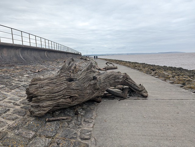
 I followed the sea wall along and under the Second Severn Crossing, a.k.a. the Prince of Wales Bridge, which carries the M4 Motorway to and from Wales, supplementing the 1966 Severn Bridge which can be seen further upstream. The tide was partly out and the path along the concrete wall was littered with bits of tree, some quite large, washed down from inland.
 
 Driftwood, Severn Beach
 
 After passing under the M4 and I reached New Passage Pier. This used to have a railway terminus and ferries across the Severn before the 4.4 miles long Severn Railway Tunnel superseded them in 1886. There is an information board at the point where you walk over the site of the tunnel. Beyond New Passage I turned inland to follow the Severn Way along The Pill river but soon and to backtrack because someone had let the cows out. The cows themselves weren’t the problem, the fact that the ground wasn’t yet firm enough to support them was since they had puddled the surface into an impassable quagmire and when the mud reaches over the top of your boots it’s time to change your plans. Even the cows didn’t seem to be enjoying the conditions. I re-routed via New Passage Rd. crossing the M4 in what according to the signs visible from the over bridge appears to be a no man’s land between England and Wales, and after a couple of miles reached Pilning. Well to be accurate I reached The Plough, where I was glad to have time to enjoy a pint of Wadworth’s and where they didn’t seem to mind the mud splattered apparition that just left a visible trail in and out of their saloon bar.
 
Pilning Station
 
Pilning is a formerly quite important station on the South Wales Main Line between Cardiff and Bristol. Potentially it could be an important transport hub for the surrounding area. Currently it’s the ninth least used station (2022-2023 figures) in England though due to under investment, poor management, and reduction in services that looks very like an attempt at closure by stealth. Until 2015 there were two trains a day, one in each direction. In 2016 that was reduced to two a week, the minimum permitted under the operator’s franchise. In November 2016 as part of the Great Western Mainline electrification the footbridge to Platform 1 was removed and the decision made not to pay to replace it. So now the two trains a week run in the same direction, towards Bristol, on a Saturday timetabled at 0832 and 1532. To make a return journey from Pilning you need to leave early in the morning and return early in the afternoon travelling to Severn Tunnel Junction and then back to Pilning. It being Saturday and GWR it’s not unknown for the trains to be cancelled. You can see why the locals are not happy. The publicity around the above has, because UK rail enthusiasts being what they are, resulted in something of an upturn in passenger numbers though and Pilning refuses to die. I added 1 to the statistics. Why? Because it’s there of course.
 
 Welcome to Pilning Station
 
 Fortunately I only needed to make a single journey from Pilning to Bristol Temple Meads, cost with a railcard £3.60 and scheduled to take 20 minutes. Why the 37 minute trip from Bristol Temple Meads to Severn Beach earlier only cost £1.35 is a mystery known only to the gods of the UK rail ticketing system. I arrived in good time to take a look around. There’s not a lot to look at.
One platform, unlit because no one would replace the unsafe lighting and so trains cannot call after dark. One small shelter with a seat. This was actually occupied on my visit by the other two passengers travelling from Pilning that afternoon!
 
 Pilning Station
 
 An information point and a train times poster pretty much completes the set. There’s one station name sign ideal for selfies wearing your “#footbridge4pilning” tee shirt. No, I’m not sharing it here 😜
 
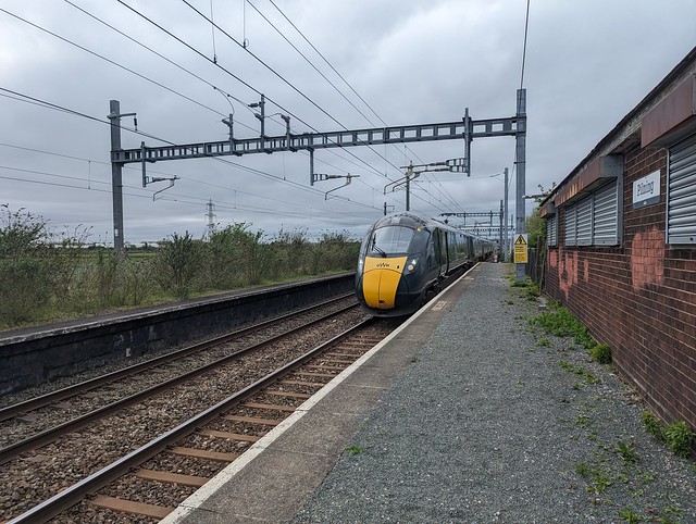
A couple of trains passed through while I was waiting, one in each direction. There’s no train departure board at Pilning obviously so I was keeping an eye on the Train Track app on my phone - fortunately something Pilning does have is a decent mobile signal. So I wasn’t entirely surprised to see that the 1532 train was now shown as “Delayed” with no estimate of when I might arrived. Told you, GWR + Saturday. Eventually it’s ETA was given as 1546 which kept moving away until 1549, which is when it finally appeared.
 
 Second train of the week, Pilning Station
 
 This train from Cardiff Central to Penzance in Cornwall had left Cardiff late and was quite well loaded. Interestingly I had a seat reservation, Coach C Seat 78, but although the seat was vacant that was only luck since the reservation wasn’t shown on the on board display above the seat. (GWR+Saturday again?). Anyway it got to Bristol Temple Meads 19 minutes late so I got a refund of… 90 pence. Not enough for a coffee sadly.
 
Pilning ✓
 
I headed into Bristol city centre to buy a brush to remove at least some of Gloucestershire from my boots and jeans and then get something to eat. I had intended to return to the Nova Scotia later but frankly I was knackered having totted up a dozen miles walking and fortunately I had made provision in the handy fridge in my hotel room for such an eventuality. And that’s a really big television at the foot of the bed to fall asleep in front of.
 
 
 Trip to Pilning