Showing posts with label River Thames. Show all posts

Tuesday, 17 December 2024

Urban West London Ramble

16th December
 
December is dull. Grey overcast skies under which the huddled multitudes scurry spending money on presents for people they probably don’t much like. A shortage of daylight limits travel opportunities and everywhere is doing xmas tackiness. You might think that I dislike this time of year. You’d be right. Anyway I made an effort to get out of the house and immediate surroundings and took a train to Richmond without much of a plan of what to do once I got there. Inevitably it turned into an urban ramble passing through Isleworth, Syon Park, and Brentford eventually getting to Kew Bridge at dusk and catching a number 65 bus back to Richmond. I was even home in time for tea.
 
Who’s afraid of...
 
I walked through Richmond town centre down to the riverside near Richmond Bridge where I bumped into the controversial and troubled writer Virginia Woolf. Well not the real one obviously since she died in 1941 but a statue seated on a bench beside the river. The Richmond connection being that the town was her home during the Great War, after moving out of London and before the move to Sussex where she ultimately ended her life by walking into the River Ouse near Rodmell. You could sit next to her on the bench but she doesn’t look like you’d be welcome to do so.
 
 Virginia Woolf
 
 I sat on a nearby bench instead and then decided to walk along the river towards Kew.
 
Crossing the Thames
 
At Richmond Lock the riverside path was closed so I crossed over the Thames on the ornate Grade II* listed Richmond Lock Footbridge to St. Margarets on the west bank (north bank?) and turned right towards Isleworth.
 
 Richmond Lock Footbridge
 
 It was an hour or so before high tide but already the water was beginning to spill across the edge of the riverside footpath by The Boathouse so i was glad to reach the slightly raised grassed area of Isleworth Promenade. No I didn’t know Isleworth had a prom either. It’s entirely devoid of amusement arcades, candy floss stalls or Punch and Judy however, just a broad grassy strip alongside the river leading towards Thisleworth Marina (not a spelling error) where there’s no access to the riverside and you have to bear away to cross the River Crane at the Richmond Road bridge, about a hundred yards from its confluence with the Thames. 
 
I returned to the river’s side at Lion Wharf with a blue crane and a stack of pallets and other materials showed that this is still a working river, as does the number of barges moored nearby and the commercial buildings on the edge of Isleworth Ait.
 
 Crane, Lion Wharf, Isleworth
 
I turned left and walked past the boats to Town Wharf where the Thames Path and Capital Ring Section 7 pass through the Town Wharf pub, or at least the outside terrace area that they’ve built across the riverside footpath and carried on until I reached The Duke of Norhumberland’s River.
 
Old Isleworth
 
The Duke of Northumberland’s River is named after Henry Percy, 9th Earl of Northumberland although he didn’t build it, he inherited it from his wife Dorothy Devereaux upon marriage. It is an artificial watercourse which distributes water from an old acquaintance of this blog, the River Crane, at Whitton and by a roundabout route brings it to Isleworth where it used to power a mill and by way of a system of sluices fills the ornamental ponds in the Duke’s nearby estate Syon Park. To cross it’s outflow into the Thames by Isleworth Ait there’s an old stone bridge at Mill Plat on Church Street which leads into Isleworth’s old riverside. Although the bridge is almost surrounded by modern flats now.
 
 Mill Bridge, The Duke of Northumberland's River, Isleworth
 
 Church Street is blocked to through traffic save for pedestrians and cyclists though I can remember when it wasn’t. It now forms a long cut-de-sac with the open end at the river by the London Apprentice pub. I might have stopped for a swift one but wanted to carry on while there was still plenty of daylight left.
 
 Church Street, Isleworth
 
Although I did pause for a while along with everyone else by Isleworth Drawdock where a crane was unloading a container from a barge and depositing it at the roadside. There seemed a good chance they’d drop it on themselves, the dog, or the adjacent parked van but eventually they wrangled it into place. It was a bit like a scene from an earlier time since they eschewed PPE and any kind of guarding to keep the public out of harm’s way. A HSE inspector would have had a fit.
 
 Crane operation, Isleworth Drawdock
 
 Syon Park
 
I passed The Isleworth Parish Church All Saints, which is an uncomfortable mix of 14th century tower and late 1960s modern because on the night of 27th May 1943 the church was gutted by fire; arson at the hands of two local schoolboys. Only the tower and outside walls survived. Rebuilding commenced in 1968 and was completed in 1970.
Skirting the churchyard on the raised walkway - the road often floods, along with the cars of anyone unfortunate enough to be using the riverside car park - I entered Syon Park  through the gate in Park Road and followed the path towards Syon House. As I did so it occurred to me that the last time I’d walked this way was with my maternal Grandad. So I’d have been at most 8 years old. Grandad used to take me and sometimes my little brother for long walks from Myrtle Road, Hounslow, sometimes to Osterley Park but I clearly recall going to Isleworth one day and through Syon Park to Brentford. I expect Gran wanted him (and probably us) out from under her feet else he’d be in his armchair smoking Guards fags and we’d be being told off for playing with the mangle in the scullery 😀
 
Anyway back to 2024. Here’s Syon House, the west London residence of the Duke of Northumberland. A Grade I listed building, it lies within the 200-acre (80 hectare) Syon Park. These days it shares the park with a big garden centre and its car park and a Hilton hotel. It’s still not a bad pad for a Duke’s not-quite-country-any-more-etreat though it’s a shame they built it under the Heathrow flight path...
 
 Syon House
 
 One day I must pay a visit to the inside but it’s shut in the winter. I left the park onto the London Road and made a short diversion to look at the rude lion.
 
 The Lion Gate, Syon House
 
 Syon House's 'Lion' Gate is widely recognised. The row of arches, topped off with a lion which originally stood on top of Northumberland House on Strand, the Dukes of Northumberland's town house. The popular story goes, which was also told to me by Grandad Kimbell, is that its arse pointed towards Clarence House as an insult after the Duke of Northumberland fell out with the then Prince of Wales. The Lion Gate was designed by Robert Adam c.1769, oddly in Adam's original drawings the tail hung down naturally rather than being raised and pointing straight. 
 
Brentford, battles and boats
 
I retraced my steps and continued in the direction in which the lion’s head is looking, towards Brentford town centre. One of the joys of walking around the streets is that you learn things in passing that you never knew. This time it was finding a plaque on the old brick boundary wall of Syon Park commemorating the fact that in 1616 – 1617 Pocahontas, a Native American woman, belonging to the Powhatan people, resided in Brentford with her husband, John Rolfe and son Thomas. You might know her from a Disney film. Or if you’re like me you’ll be reminded of Julian Clary’s “what’s a Hontas?” quip 😉
 
 Memorial to Princess Pocahontas, london Rd. Brentford
 
 In November 1642 a Royalist army advancing on London overcame a much smaller Parliamentarian force in battle at Brentford. The town was ransacked in the immediate aftermath of the engagement. Now cynical types might suggest that parts of it haven't been repaired since but that's just the current round of regeneration. Having driven the Parliamentary forces out of Brentford the Royalists advanced to Turnham Green where there was a stand off between them and a large Parliamentary force. But the Parliamentary commanders didn’t think that their troops were trained well enough to risk an attack and and the King decided not to press his advance on London by giving battle against a greater force. He decided, as it was near the end of the campaigning season, to retreat to Oxford where his army could be billeted over the winter. Had the King pressed on the course of history might have been very different. Here’s a view downstream from Brentford Bridge under which the River Brent flows and over an earlier version of which Prince Rupert’s troops advanced. According to Grandad somewhere along that left bank stood the street and the house where Gran was born.
 
 Grand Union Canal, Brentford
 
 I stopped for a coffee in Brentford High Street before pressing on back to the riverside at Ferry Wharf where the River Brent/Grand union Canal make their confluence with the Thames having passed through Brentford Docks. In the back channel around Lot’s Ait are many houseboats and a boat building yard. Apparently some scenes in The African Queen were filmed at Lot’s Ait. I’ve no idea if that's true though some of the film was shot in Isleworth Studios which gives rise to the persistent urban legend that Isleworth is the origin of London’s parakeet population. Almost certainly not true.
 
 Dahlia Bridge, Lot's Ait, Brentford.
 
 I walked through Waterman’s Park, formerly part of Brentford Gas Works, noting that all but one of the wrecks has now been removed from the river pending redevelopment of the moorings. That can’t go ahead until they work out how to remove the last vessel which is so structurally unsound it can’t be re-floated. Everything is now tied up in red tape waiting permission and environmental mitigation plans. Oops.
 
 Wreck, Waterman's Park, Brentford
 
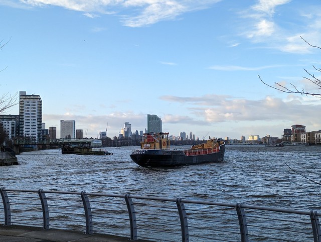
 As daylight faded I passed the tall tower of the London Museum of Water and Steam (aka Kew Bridge Steam Museum) and arrived at Kew Bridge just in time to hop on a 65 back to Richmond station.
 
 
 An Urban Ramble, Richmond to Brentford.
 

Sunday, 7 July 2024

Footpath 47

 I had a bit of time on my hands so I took a random ride out to Barking Riverside to see if it had changed much since my previous visit in August 2022 not long after the new station opened. Back then it was very much a building site.

Barking Riverside

 Now? Still a building site really, a bit tidier but not a lot going on on a Friday afternoon.

Barking Riverside Station

The area outside the river side of the station is a bit more finished and there's a horse box, which I assume dispenses coffee at some unspecified times but it wasn't open. I took a stroll down to the riverboat pier again but this time it was chained shut it being about 4 p.m. and there being no boats between 11:35 and 17:12 on a weekday.

Barking Riverside Pier

So no escape that way. Not wanting to get straight back on the train I looked for something else to do and found Footpath 47 signposted from the "esplanade" near the pier. It's not a long walk, roughly a mile, but it takes you along the river side eastwards along what is currently a grassy bank with a large open space fenced off on the landward side which no doubt one day will be covered in blocks of identikit flats. Best make the most of this prime outdoor facility while it's here then. 

The Thames is around half a mile wide here giving a view over to Cross Ness and the water works which I visited in 2019 and more prominently the white and blue Belvedere Incinerator at the Riverside Resource Recovery Energy from Waste Facility, turning London's rubbish into power.

Footpath 47, looking towards Cross Ness

There was a fairly strong south-westerly breeze coming across the river, bending the long grass and short, scrubby trees on the riverbank but not disturbing the birds feeding on the exposed mudflats below - although they did all take care to keep their heads pointing into the wind.

Footpath 47, seabirds on the mud


Looking back past Barking Riverside Pier the horizon was studded with south east London towers and the cranes at the new Barking Riverside developments.

Footpath 47, looking back from Horseshoe Corner

Intermittently aircraft bound for London City Airport made their way westwards following the Thames. Despite which it feels quite remote out here and is fairly quiet. I'm sure that will change as the flats and houses get closer.

Footpath 47, Lufthansa to London City

After half a mile or so Footpath 47 reaches Horseshoe Corner where it turns inland to follow The Gores stream from its confluence with the Thames up a short valley with reed beds in the bottom to come out on Choats Road. The far side of The Gores is very different to the Footpath 47 side for here are the industrial estates of Dagenham Docks, with an aggregate plant blocking any further Thames side progress.

Footpath 47, art thing, Horseshoe Corner

Over a high bank and a fence on the left of the path I could just make out ground works beginning on what The Masterplan for Barking Riverside describes as The Village – On The Horizon. With plenty of family homes and located close to the local schools and shops, The Village is an ideal neighbourhood to raise a family. The area also benefits from plenty of green spaces and long views over the River Thames.

Which is a good example of what Diamond Geezer refers to as "bolx".

Footpath 47, The Gores & Dagenham Docks Biogas

The stretch of path from Horseshoe Corner to Choats Road starts out quite flowery with a lot of what Google Lens tells me is Goat's Rue and finishes very littery at the point where you squeeze out between substantial chunks of metal embedded into the ground, there to prevent the entry of motorbikes I suppose.

Footpath 47, Goat's Rue, The Gores.

I squeezed out, turned left and walked down to the bus stop by the BRL Infrastructure Office where I caught the EL2 to Barking Station.

I can now say I've walked the remote Footpath 47 while it's still (relatively) remote and if you're anywhere nearby you should too, although to be honest it's not worth a special trip form afar.

I've put some more photos on Flickr

Footpath 47

Wednesday, 11 January 2023

Along the Ravensbourne to meet a Tzar.

9th January 2023

I started my first urban ramble of the new year at Catford Bridge railway station, a three train ride away from home. Leaving the station on the wrong side I crossed the tracks on the Catford Road bridge and turned right into Adenmore Road past the disused station building and left under the railway to my first sight of the River Ravensbourne in its concrete sided channel at the footbridge into Ladywell Fields. 
 
 Along the River Ravensbourne, Ladywell Fields.
 
I followed the path through Ladywell Fields back across the river and back under the railway into the northern part of Ladywell Fields where the Ravensbourne is less constrained in its course and out along Malyons Road, a long straight South London residential street developed in the early 20th century, One right were large two storey terraced houses and on the left similar but with some being maisonettes, the giveaway being the two front doors set back under the arched porches.
 
I had plotted a route on the map before leaving home but at the top of the road realised that I was more or less following the Waterlink Way and since this is well way marked from here on I followed the signposts and pavement roundels. These led me through local streets away from the inaccessible river to meet it again albeit briefly in Cornmill Gardens before it disappeared beneath Lewisham town centre.
 
 Along the River Ravensbourne, Lewisham.
 
Following the WW signs round the end of Lewisham Bus Station and through the tunnel under the railway I next saw the Ravensbourne over a brick wall where it runs parallel to the DLR past Elverson Road station and then into Brookmill Park.
 
 Along the River Ravensbourne, Brookmill Park.
 
Brookmill Park held the welcome prospect of a Public Convenience but this is Britain in the 21st century so despite being shown on the map at the park entrance these proved to be locked up and to all appearances permanently closed. Still the lake was nice, it’s probably much busier in summer than January, the only person I encountered being the council street-sweeper who was taking pictures of the fallen tree across the path that prevented him getting his machine through.
 
 Along the River Ravensbourne, Brookmill Park.
 
From the top of Brookmill Park the way leads to Broadway Fields, across the Ravensbourne and beneath the elevated DLR into Deptford town centre. At Deptford Bridge you can see the Ravensbourne heading under the DLR but need to walk via local streets for some distance before rejoining it at Deptford Creek, north of Creek Road. We’re close to the confluence with the Thames here but public access to the waterside at Deptford Creek itself is very limited.
 
 Along the River Ravensbourne, Deptford Creek.
 
At the point where the Deptford Creek/River Ravensbourne meets the Thames there has been much new development. Handily this includes a Waitrose so I popped in and got a picnic lunch to eat by the riverside. The great writer and film maker John Rogers whose youtube videos partly inspire my urban walks would point out that the confluence of two rivers is a sacred place. He’d traditionally grab a can of Stella and a vegetable samosa for lunch but I’m not a fan of the former and Waitrose hadn’t any of the latter so I settled for a fancy veggie wrap and a diet coke. Eaten on a bench near the Oystercatcher bar outside which the landlady was walking a cat on a lead.
 
 Along the River Ravensbourne, Deptford Creek.
 
This was followed by a stop for coffee in Costa in no way prompted by the desperate need to use their loo. Refreshed and relieved I resumed my walk west along the Deptford river front but had to wait for the pedestrian swing bridge across the entrance of the creek to be swung back into place. The bridge had been opened to allow the exit into the Thames of the aggregate carrier Bert Prior, built in 1961 in the Netherlands and still plying the North Sea and Thames Estuary 62 years later.
 
 The Bert Prior exiting Deptford Creek.
 
On the west side of Deptford Creek there’s a monument to someone that you might not immediately associate with Deptford. A memorial to the Russian Tsar Peter the Great was erected in London in 2000 to commemorate the tercentenary of his visit to England in 1698. During his stay he met members of William II's court in England, and visited the Royal Observatory at Greenwich, the Royal Mint, the Royal Society, the University of Oxford, and various shipyards and munitions factories, including Deptford. Peter travelled with a huge entourage and for much of his visit resided at John Evelyn’s house Sayes Court near Deptford Dockyard. Evelyn had leased the house to a naval officer John Benbow who sublet it to the Tsar. Unfortunately during the stay Peter and his entourage trashed the place, damaging all parts of the property, the floors, walls, and doors, breaking furniture and windows and destroying soft furnishings, bed linen and the garden. Hundreds of pounds worth of damage was done, the equivalent of tens of thousands today. There must have been an awkward conversation between Benbow and his landlord! Although Evelyn sought and was granted compensation from the government.
 
 Peter The Great memorial at Deptford.
 
(The statue of Peter the Great depicts him with a very small head. Maybe he was the original man in the joke involving a mermaid granting a wish that you’re going to have to search for because I’m not repeating it here ;-)  )
 
Sayes Court House has long gone along with most of its gardens but as I followed the Thames Path west through Sayes Court Park, the remains of the gardens, I passed the ancient Mulberry tree some have said was planted or gifted by Tzar Peter the Great. I’m not sure that idea ties in with his other reported behaviour. The tree is in poor condition but reportedly still bears fruit.
 
 Mulberry Tree, Sayes Court Park, Deptford.
 
 My feet weren’t ready to stop walking so I carried on along the Thames Path to Rotherhithe where as the daylight waned I caught a bus back to Waterloo Station but that’s beyond this tale.

Saturday, 31 July 2021

The Source of the River Thames


Monday 26th July 2021

We’d got back our “freedom” and the rain had let up for the day at least according to the forecast. Time to pick a random destination and get back on the rails.
 
The source of the River Thames lies in a remote meadow near the village of Kemble in Gloucestershire - which used to be in Wiltshire. At least the official source is, some argue that it’s actually at Seven Springs about 11 miles further north at the source of the river Churn because that flows into the Thames and is further from its mouth. That would make it the longest river in the UK but must be wrong otherwise surely the river that runs through Reading,Oxford (yes, I know, Isis), and London wouldn’t be called the Thames and the rowing regatta would be held at Henley-on-Churn. Also the former TV channel would have been Churn Television although you could argue that would have been more apt.
 
Anyway the source in Trewsbury Mead has an official memorial stone and a signpost and all that so ignore the pedants. It’s also conveniently not too far from a railway station (Kemble) and a pub so that’s where I went to find the start of the longest river in England. No, the Severn is partly in Wales so you can delete the comment you were about to write.
 
 GWR Class 165 at Sandhurst
 
We now have a somewhat irregular service pattern on our railway line, introduced last year to go with the replacement trains that we haven’t got yet, which means that as far as I can make out the first off-peak service to Reading, to connect with the GWR main line, is at 1026. That would have got me to Kemble at 1140, plenty of time to walk to the source and then go and have a pub lunch. Unfortunately as well as being irregular the service is unreliable and that train was cancelled due to a points failure and the next was consequently about 20 minutes behind schedule arriving at Reading just in time to watch the 1153 to Kemble (the one an hour later than the one I should have been on) depart from platform 7. There is no 1253 train from Reading that stops at Kemble so I had to go to Swindon and wait for a train to Kemble that started there. Actual arrival at Kemble was 1341 a bit late for lunch (good job i’d bought a picnic on the way) but just qualifying for a 100% Delay Repay refund on my ticket. I’d have preferred to have been on time.
 
 Kemble Station showing the start of the abandoned Cirencester branch line to the right.
 
Kemble Station is small, with long platforms and a large water tower at one end of the down platform in traditional if faded GWR colours. Since this part of the line hasn’t been electrified it also still has its iron lattice footbridge linking the two platforms, not yet replaced in order to provide space for overhead wires such as has happened elsewhere. From the road bridge on the London side a spur of track can be seen leading off to the north. This is the remains of the Cirencester branch line, opened by the Cheltenham and Great Western Union Railway in 1841 and closed on 4th October 1965. This branch crossed the course of the River Thames north of Kemble at about where the A429 does now, making it then the highest/uppermost rail crossing on the river.
 
It’s about a mile and three quarters (2.8km) from Kemble Station to the source of the Thames, leaving the station north car park and turning left for a few yards then right onto a broad grass footpath and you are off the road for the rest of the walk except for crossing the A433.
 
© OpenStreetMapcontributors
 
A little way before getting to the A429 there’s a Thames Path sign pointing left over a wooden footbridge and shortly after you are following the River Thames. It might be a little difficult to spot unless there’s been a lot of rain though. On my visit it was visible only as a reed-filled ditch about 3 yards across.
 
 The River Thames, only a reed-filled ditch here.
 
Further along the path crosses a farm track which itself crosses the Thames on a sort of low bridge or culvert, so water must flow here in some quantity at times although it was bone dry today.
 
 The first "bridge" over the Thames, albeit very dry today.
 
The Thames Path rises to cross the A433 Tetbury to Cirencester road near where it crosses the Thames, which it the highest road crossing on the river although in contrast with the lowest crossing it requires neither bridge nor tunnel to do so, the river being small enough to be culverted so it’s hard to work out where the actual crossing is.
 
 At the A433, the highest road crossing the River Thames, or at least the course of it.
 
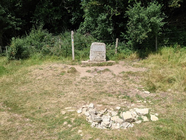
I followed the clearly marked path that climbed gently across the fields of Trewsbury Mead to the obscure corner the edge of the woods where the stone memorial and a pile of rocks in a shallow depression mark the official, accept-no-substitute Source Of The River Thames.
 
 The Official Source of the River Thames
 
The inscription on the stone, unreadable due to wear and bright sunlight, reads
 
"The Conservators of the River Thames
1857 – 1974
This stone was placed here to mark the
Source of the River Thames".
 
Alongside the stone is the first (or last) Thames Path footpath sign, pointing the way down the 184 miles of the national trail to the barrier at Woolwich, which is definitely a lot noisier and busier than this end. I ate a solitary picnic against the only suitable tree that I could find to shelter under from the now quite hot sun, not even disturbed by the middle-aged couple walked down from the other direction, took their selfies, and returned the same way.
 
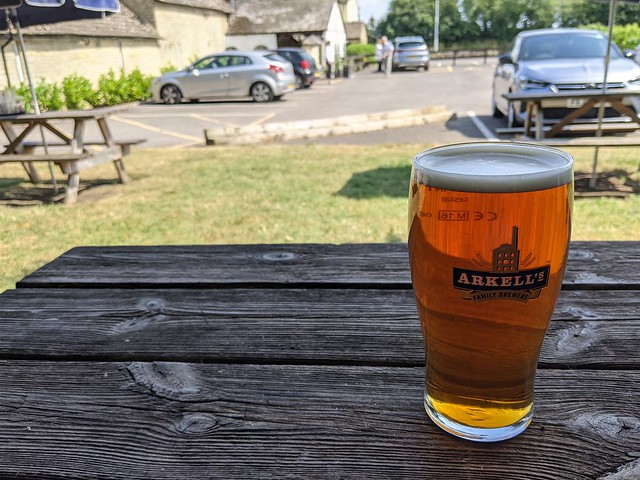
Then I returned along the Thames Path to the A433 and turned right along the road and under the railway to the Thames Head Inn. Because it would be rude not to really. It was the first time I’d set foot in a pub for over a year due to you-know-what but i remembered how it worked and enjoyed a nice pint of Hoperation IPA (ABV: 4.2%) sitting in the shade in the beer garden. I might have had another but had a train to catch from Kemble three quarters of a mile away down a country lane. A train which actually ran on time, as did the connection at Reading, making a better end to the day out than the beginning. 


 A welcome refreshment at The Thames Head Inn.

Tuesday, 22 September 2020

Hammersmith & Fulham Self Guided Walk

Sunday 20th September 2020

London Open House this year was obviously affected by you-know-what and as part of that published a number of self-guided tours which you could (and at the time of writing still can) download and follow at your own pace and at your own time. So as it was reasonably easy to get to and looked interesting I picked the Hammersmith & Fulham route for a Sunday afternoon explore.
Hammersmith & Fulham Self Guided Walk
Along the route of the self-guided walk by Open House London 2020.
open-city.org.uk/selfguided-tours
Hammersmith & Fulham Walk - Stamford Brook Station Stamford Brook Tube Station (District Line), W6 0SB The District Railway has operated through here since 1869, but this station was only built in 1912. The tracks were doubled in the 1930s to accommodate the extension of the Piccadilly Line. London’s first automatic ticket barrier was installed here in January 1964. Out of the Oyster gate, de-mask, and cross the road and turn right, then left into King Street and right into St. Peter's Church.
Hammersmith & Fulham Walk - St Peter’s Square St. Peter's Square. The first houses to be built in the square were on the northern side, with the whole square complete by 1830. The statue in the middle of the garden, erected in 1926, is The Greek Runner, by Sir William Blake Richmond who lived locally. He also designed the mosaics in St Paul’s Cathedral.
Hammersmith & Fulham Walk - St Peter’s Square Having walked south through the gardens at an appropriate social distance from the picnickers I emerged into the street and turned left towards the church.
Hammersmith & Fulham Walk - St Peter’s Church, Black Lion Lane St Peter’s Church (Edward Lapidge) is in Ionic style with an impressive set of columns. I cut south through Verbena Gardens to the A4 Great west Road.
Hammersmith & Fulham Walk - “Draped Woman”, by Karel Voge Right next to the A4 is a cast concrete statue: “Draped Woman”, by Karel Vogel. Studio magazine said in 1962 that it “expresses his intention in a floating movement, repeating the curve of the road and taking up the slope of the opposite subway”. If you say so. I passed under the busy A4 via the subway into South Black Lion Lane.
Hammersmith & Fulham Walk - South Black Lion Lane On the left is the Black Lion pub which was doing a good Sunday lunch trade. Further down the lane, at the Thames, are Bell Steps: Here, Frederick Bell ran a ferry across the Thames (which is tidal down to Richmond).
Hammersmith & Fulham Walk - Blue Plaque, Edward Johnston To the right of Bell Steps is Hammersmith Terrace. One of the houses has a blue plaque commemorating Edward Johnston, CBE (11 February 1872 – 26 November 1944), the British craftsman and calligrapher most famous for designing the sans-serif Johnston typeface that was used throughout the London Underground system until it was redesigned in the 1980s. He also redesigned the famous roundel symbol used throughout the system.
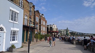
Hammersmith & Fulham Walk - River Thames from Bell Steps From Bell Steps I turned left to follow Upper Mall alongside the Thames. The Old Ship Inn on Upper Mall dates from about 1722 and was also making the most of the sunshine before our PM decided to scapegoat pubs for the increase in Covid19 infections.
Hammersmith & Fulham Walk - Upper Mall Following Upper Mall the footpath passes under the first floor of some 1960s houses which front onto Oil Mill Lane and back right onto the river.
Hammersmith & Fulham Walk - Linden House, Upper Mall Further along Linden House which dates back to the 18th century and is the headquarters of the London Corinthian Sailing Club. It has a prominent flagpole (mast?) and apparently a problem with bicycle thieves.
Hammersmith & Fulham Walk - Sailing Club race starting box On the river side of the path is London Corinthian Sailing Club's race starting box, which won a Civic Trust award in 1964.
Hammersmith & Fulham Walk - Blue Plaque, Eric Ravilious At the junction of Upper Mall and Weltje Road is a blue plaque commemorating locally born artist, Eric Ravilious who lived at 48 Upper Mall in the 1930s.
Hammersmith & Fulham Walk - Rivercourt House A number of the buildings along the next stretch of Upper Mall are used by Latymer School, including Rivercourt House. Also a man having a fight setting his motorcycle alarm, with the number of people walking, scooting, and cycling along here it was anything but peaceful.
Hammersmith & Fulham Walk - Upper Mall Amongst the older mostly brick-built houses No.28, the lower building on the left of the picture is one of the few modern buildings on Upper Mall.
Hammersmith & Fulham Walk - The Dove pub 19 Upper Mall Where the road narrows to challenging social distancing width is the Dove pub at 19 Upper Mall. The pub, owned by Fullers since 1796, has one of the smallest bars in England. There is a terrace overlooking the Thames.
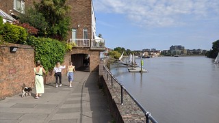
Hammersmith & Fulham Walk - Dove Pier Beyond the pub lies Dove Pier at the corner of Furnivall Gardens where there are houseboats moored at the pier and along the riverbank.
Hammersmith & Fulham Walk - Furnival Gardens Furnivall gardens were established after WW2 on the site of rundown industrial buildings and Hammersmith Creek, which was filled in in 1936. Stamford Brook reached the Thames here, and barges docked along the creek right up to King Street. There was too long a queue for the ice cream van unfortunately. The gardens are a popular place to watch boat races in years when that is allowed.
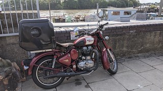
Hammersmith & Fulham Walk - Royal Enfield From India to Fulham. With added pet carrier. For cat or dog (or maybe just pizza) I don't know.
Hammersmith & Fulham Walk - Westcott Lodge The first house after Furnivall Gardens is Westcott Lodge, set back slightly from Lower Mall. Previously the vicarage of St Paul’s Hammersmith, which is just the other side of the flyover and which the walk passes later on.
Hammersmith & Fulham Walk - Furnivall Sculling Club
Hammersmith & Fulham Walk - Lower Mall
The next stretch of Lower Mall was fairly busy. Here is Furnivall Sculling Club Dr Frederick Furnivall (who originated the Oxford English Dictionary) founded The Furnivall Sculling Club for girls in 1896. Men could join from 1901. On the corner of Mall Road are two pubs with a rowing club between them: The Rutland Arms (1870, lost its top floor in WW2), Auriol Kensington Rowing Club (formed by amalgamation in 1981), and The Blue Anchor (licensed from 1722, and one of the oldest pubs in London). In another time I'd have been tempted to stop for a pint.
Hammersmith & Fulham Walk - Hammersmith Bridge
The previous photo was taken with my back to Hammersmith Bridge. Hammersmith Bridge is unwell. Designed by Sir Joseph Bazalgette and opened in 1887, replacing an earlier bridge built in 1827. It has frequently been repaired and is currently closed to all traffic including pedestrians, awaiting further extensive repairs. The towpath under the bridge is closed and river traffic is not allwed to pass under it due to the dangerous state of the structure. The coats of arms displayed at on the suspension stays at both ends of the bridge (and overpainted in green paint) are those of the City of London, Kent, Guildford, City of Westminster, Colchester, Middlesex and, in the centre, the United Kingdom
Hammersmith & Fulham Walk - Hammersmith Bridge The walking route was intended to pass under the bridge but with the path closed I had to make a short diversion up Hammersmith Bridge Road and back. This disused drinking fountain on the west side of the bridge abutment wall would have remained unseen had the path below the bridge been open.
Hammersmith & Fulham Walk - Riverside Studios Beyond the bridge and rejoining the riverside the next point of interest is Riverside Studios The site was redeveloped and re-opened as an arts centre with 165 flats above and around it (Assael Architecture) in 2019. It had been a film and BBC television studio since 1933. Amongst the first programmes made there was Hancock's Half Hour, as the show demanded a studio audience which Riverside could accommodate. During the 1950s and 60s it was the recording location for some famous programmes, including the science-fiction classic Quatermass and the Pit, early episodes of Doctor Who, and children's favourite Play School. The new building however lacks either round or arched windows to look through.
Hammersmith & Fulham Walk - Queen Caroline Street
I turned away from the river (or rather I should have done but didn't and had to retrace my steps for a bit) up Queen Caroline Street, named after the unhappy wife of George IV who lived in and had her rival court in Hammersmith. Along Queen Caroline Street are apartment blocks from three different eras, including a Peabody Trust estate.
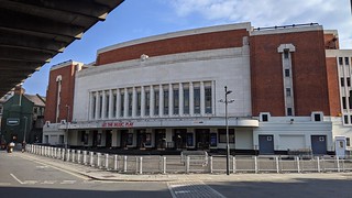
Hammersmith & Fulham Walk - Hammersmith Apollo At the top of Queen Caroline Street on the right and facing the flyover is the Hammersmith Apollo (now called Eventim Apollo). Designed by Robert Cromie in Art Deco style, it opened in 1932 as the Gaumont Palace, being renamed the Hammersmith Odeon in 1962, and became an important live music venue, featuring Buddy Holly, Miles Davis, Riverdance and SpongeBob SquarePants, among many others. The 1932 pipe organ was restored in 2007, and the building was refurbished by architects Foster Wilson in 2013.
Hammersmith & Fulham Walk - Hammersmith Flyover It's impossible to miss the Hammersmith Flyover. Although I've driven over it many times I'd never stood under it before today. The flyover was designed by G. Maunsell & Partners, and completed in 1961. It speeds up traffic from Earls Court to the Great West Road. It needed remedial work between 2010 and 2015, with weight restrictions on vehicles using it during that time.
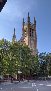
Hammersmith & Fulham Walk - St. Paul's Church Right next to the flyover is St. Peter's Church. The church is designed in the Early English Gothic Style, with lancet windows, powerful buttresses, a high roof and an imposing tower.In July 1882 the Duke of Albany laid the foundation stone, and the nave of the new church was consecrated on 13 October 1883. The architects were J. P. Seddon and H. R. Gough. Like St Peter's Church in Hammersmith, St Paul's lost a significant portion of its land, including that with graves, when Hammersmith Flyover, which can just been seen at top left of the picture, was built.
Hammersmith & Fulham Walk - Hammersmith tube station (District and Piccadilly lines) Across from the church is the end of the walk at Hammersmith tube station (District and Piccadilly lines). Parts of the old facade of the original station were re-used in the design of the interior of the station’s new north ticket hall, which was rebuilt in the 1990s by Minale Tattersfield. This though is the south entrance in the shadow of the flyover which handily leads through the small shopping centre where I puchased a late lunch and headed back down to the river to eat it before carrying on to Putney Bridge because it was only twenty to four and such a nice day for a riverside stroll.
Much of the information in this post was taken from the Open City downloadable PDF but I've added to it where some features weren't mentioned. 

More pictures are in the Flickr Album
Hammersmith & Fulham Self Guided Walk

And just for giggles I've plotted the route on this Google Map