Showing posts with label footpath. Show all posts

Monday, 17 June 2024

London Loop Section 14

Moor Park to Hatch End
 
"A very green and quite short section” says the guide. Thus encouraged having completed Section 13 instead of doing the sensible thing and walking to Moor Park Station, getting the Underground back to the car and being home early I chose instead to carry on to Hatch End. Only another 4 miles or so, can’t be too bad. From the path junction just outside the Moor Park Estate I headed away from the Metropolitan Line trains passing behind the trees and struck out on a broad grass path towards some electricity pylons (yes I know the correct term is towers but everyone calls them pylons) and across Sandy Lodge Golf Course. Does anything sound more Home Counties than Sandy Lodge Golf Course?
 
 London LOOP Section 14, crossing Sandy Lodge Golfcourse
 
 The route goes right across the course so there are lots of signs warning you to beware of flying balls from the left or right where you cross a fairway. Although quite what you’re supposed to do if there’s one coming at you I don’t know. I’ve no idea what the protocol is either, who gives way to whom? Golfers or walkers? Anyway I made it across without incident then through a small wood and out onto a lane and turned right down to a T junction near a petrol station. There are supposed to be fine views to the north over the Colne Valley here but they must have been hiding behind the summer foliage. Having crossed the road at the island by the petrol station and after a couple of goes found the right path, (which does not appear to have a green metal squeeze barrier that the guide indicates any more) I found myself climbing up into the woods again following the way marks until I emerged onto the tree-studded open area of South Oxhey Playing Fields, cutting straight across to a welcome sturdy bench, ideal for stopping for a drink of squash and a Twix.
 
 London LOOP Section 14, restful spot, South Oxhey Playing Fields
 
 I was undisturbed while I took a break, distant dog walkers being the only other sign of life apart from the distant houses that lay ahead. Pushing on out of South Oxhey Playing Fields and a brief bit of road walking through South Oxhey’s northern edge I entered the woods called Old Furze Field at the end of a short street called Nairn Green. I’ve been to Nairn, the town in Scotland and it’s not especially green. It is considerably less muddy than these woods though. Following the way marks wasn’t too hard but in places the going was quite unpleasant, on a few occasions the path was too gloopy and jungle-bashing was needed to find a way past. And all this time I was still going up. By the time I’d climbed up to drier ground and crossed Prestwick Road I’d renamed Old Furze Field as Fox Ache Woods in my head.
 
 London LOOP Section 14, Old Furze Field, South Oxhey
 
 At a T junction of paths in Nanscot Wood I had a decision to make. Turn left and follow Section 14 proper which the guide says some of the fields  can be impassable without wellies after wet weather or turn right to follow a route along better drained tracks and roads but missing the view over London which is probably the most notable feature on Section 14? Not without a little trepidation I turned left. Shit or bust, what could possibly go wrong?
 
 London LOOP Section 14, a view over London, Pinnerwood Farm
 
 Nothing as it turned out. The possibly impassable field turned out to be so dry that the only small risk was turning an ankle in a dried-up hoof-print. You do get a good view over London and despite it being a little hazy Wembley Arch was easy to make out and I could see the top of The Shard because where can’t you see it? I went downhill into Pinnerwood Farm yard, squeezed between the parked vehicles to locate the path out the other side through another wood and along the drives of the cottages hidden in the woods and past the early 18th century Pinnerwood House, glimpsed between the trees and across its garden pond. It was home to the novelist Edward Bulwer-Lytton in the 1830s. As well as being an author he was a politician and cabinet minister but he’s far away, buried in Westminster Abbey, probably not on a dark and stormy night fitting as that might have been.
 
A short walk along a concrete drive, left along a narrow footpath and across a couple of untidy paddocks, through a broken gate and along the back of a row of houses and I reached the signpost marking the end of Section 14 and start of 15.
 
 London LOOP Section 14, the end of Section 14, by Grimsdyke Road, Hatch End
 
London Loop Section 14 ✔︎
 
 The alleyway in the above photo took me out into suburban Hatch End where I walked to the station. I’ve no idea what was going on here with these unattended items. No one seemed to be taking any notice of them, no one appeared to be with them. Alien abduction?
 
 London LOOP Section 14, Hatch End railway station, alien abduction?
 
 Anyway the TfL Go app suggested a bus to Rayners Lane and Piccadilly Line back to Hounslow West so I left the station and hopped on the H14. Shortly after which it began raining so that was bloody good timing! It had stopped by Rayners Lane and since it was already gone four o’clock I went for coffee in Costa next to the tube station before getting the rush hour tube. Not too busy to Acton Town but predictably the first westbound train was rammed. I let it go and was delighted to find the next one was half empty. Win!
 
 
 London LOOP Section 14
 
 Not sure which section I’ll do next, they’re starting to get further away from home.
 

London Loop Section 13

Harefield West to Moor Park
 
A bit of a spur of the moment thing since the forecast was mostly dry. Parked at Hounslow West and got a bus to Uxbridge then a second one to the turning loop at Harefield West where I’d last been back in the middle of May. A short walk down the road to Summerhouse Lane and turn right to begin Section 13. Unlike the sections I’ve done so far this one is hillier and soon begins a long climb up into and through Park Wood. The path is largely fenced in but at some time the fence line must have been different because just off to one side there’s a random set of isolated cast iron gateposts.
 
 London LOOP Section 13, iron gateposts, Park Wood, West Harefield
 
 I carried on past Old Park Wood Nature Reserve, the meadows opening up on the left and then the allotments emerging onto Hill End Road. A left then right past houses and then over a stile where the terrain opened out and the path went onward across undulating fields in a most un-London like manner. It was quiet and rural following the field hedge boundaries and between each field a stile, footbridge, or a combination of the two.
 
 London LOOP Section 13, Foxgloves & Stile
 
 Crossing the border from Middlesex (I’m old enough to have been born in the County of Middlesex & for me it still exists) into Hertfordshire I passed some large farm buildings and could see a Police van parked at the far end of the track ahead. A peeling painted sign on the side of a big shed said “Police Animal Training Centre” and the signs on the paddock fences warned that “These horses will bite and kick”. Presumably if they kick you  they’ll claim that you fell down the stairs guv’ 😉
 
By the gateway the Loop turns right behind the Police van, an abandoned looking old Vauxhall Vivaro, running along the field edge parallel to the road and emerging into the car park of the Rose & Crown which looked like a nice pub but it was too early. I crossed the road and found the entrance to the tightly fenced-in footpath which led up Woodcock Hill into open fields heading towards the Nine Of Hearts Golf Course. 
 
 London LOOP Section 13, Woodcock Hill
 
 There are a lot of golf courses around here but before getting as far as the Nine of Hearts the Loop turns right into the trees onto a permissive bridleway, churned up at this point by many horses turning around since they aren’t permitted to go out into the meadow I’d just crossed. A bit of an odd equine dead end. A wide clear path leads into Bishops Wood and oh good, a bench on which to stop and eat my picnic lunch. Indeed the first place I’d come across to sit down since I got off the bus. Not much of a view though, just trees.
 
 London LOOP Section 13, a welcome seat, Bishops Wood
 
 Carrying on after a brief lunch stop I almost missed the sign where the Loop does a sharp left off the wide obvious track and heads off alongside a stream and starts weaving through the woods, fortunately quite well waymarked. In places the path has been well churned up by the horsey girls and I was glad that the recent weather hadn’t been as wet as earlier in the summer.
 
 London LOOP Section 13, where the horses have been, Bishops Wood
 
 The woods eventually opened out and I passed under the electricity pylons to reach the A404 at Betchworth Heath. The Loop turns right and follows the busy road past the Prince of Wales pub (not recommended for walkers says the route guide, I feel there must be a tale behind that) and then by the white Coal Tax Post you take your life in your hands and cross the A404 to the footpath leading into the woods the other side. It’s a sketchy place to be crossing a main road, the sight lines are not good 😟
 
 London LOOP Section 13, Coal Tax post, Batchworth Heath
 
 About a hundred yards in I met my first real obstacle, a tree fallen across the path. Not a huge tree but no way to go around it, too high to step over it, and too low to duck under it unless you’ve legs like a dachshund or are a champion limbo-dancer. I don’t qualify on either count and only by sending my rucksack through first did I manage to squeeze under without getting muddy knees. 
 
 London LOOP Section 13, awkward branch at Batchworth Heath
 
 Once past that obstacle it was easy going on sometimes grassy paths in and out of the trees until popping out between a fence and a wall into Kewferry Road, turn left, cross Batchworth Lane and join the very private Bedford Road into the very private indeed Moor Park Estate. Six square miles of gated, private residential roads with large expensive houses tucked away behind trees and hedges and gates and CCTV cameras. Lots of CCTV cameras. And restriction signs, and LED signs. You can almost smell the money and rather get the feeling you’re only allowed there under sufferance. Still, London Loop Section 13 goes straight up Bedford Road before turning right down an alleyway between high fences , so sod ‘em. 
 
 London LOOP Section 13, Moor Park Estate
 
 I risked taking one photo then passed underneath the Metropolitan Line to find the metal barrier and fingerpost that marks the end of Section 13. Straight on to go to Moor Park Station or bear right to continue onto Section 14 to Hatch End. I bore right but that’s another blog post to come.
 
Still, London Loop Section 13 ✔︎
 
 
 London LOOP Section 13


Tuesday, 9 June 2020

Level Crossing Closure

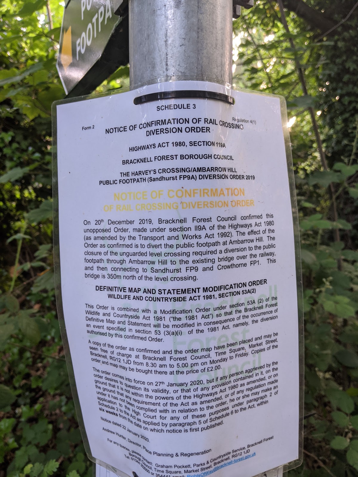
Sandhurst’s local level crossing has been closed. It’s quite likely that a majority of local residents didn’t even know that there was a level crossing being that it was on a footpath in the woods. Indeed until last year neither did I until I spotted on a map that a footpath crossed the railway near Ambarrow Wood and went to take a look. I found that it was fenced off and temporary closure notices were in place. A walk up that way yesterday evening to see if it had reopened revealed that the closure was made permanent in January 2020
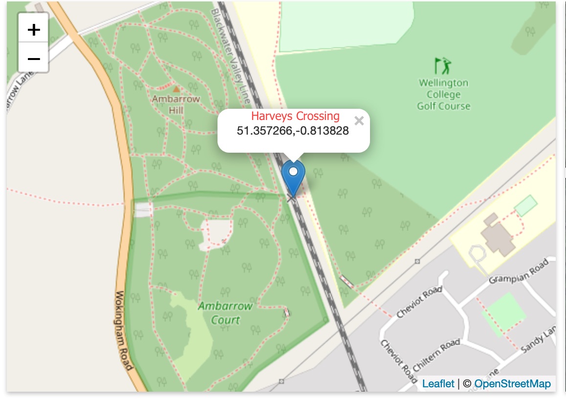
Harveys Public Level Crossing crosses (or rather crossed) the Reading to Guildford railway line south of Crowthorne Station on the West side of Ambarrow Court
Map of Harveys CrossingMap copyright OpenStreetMap contributors
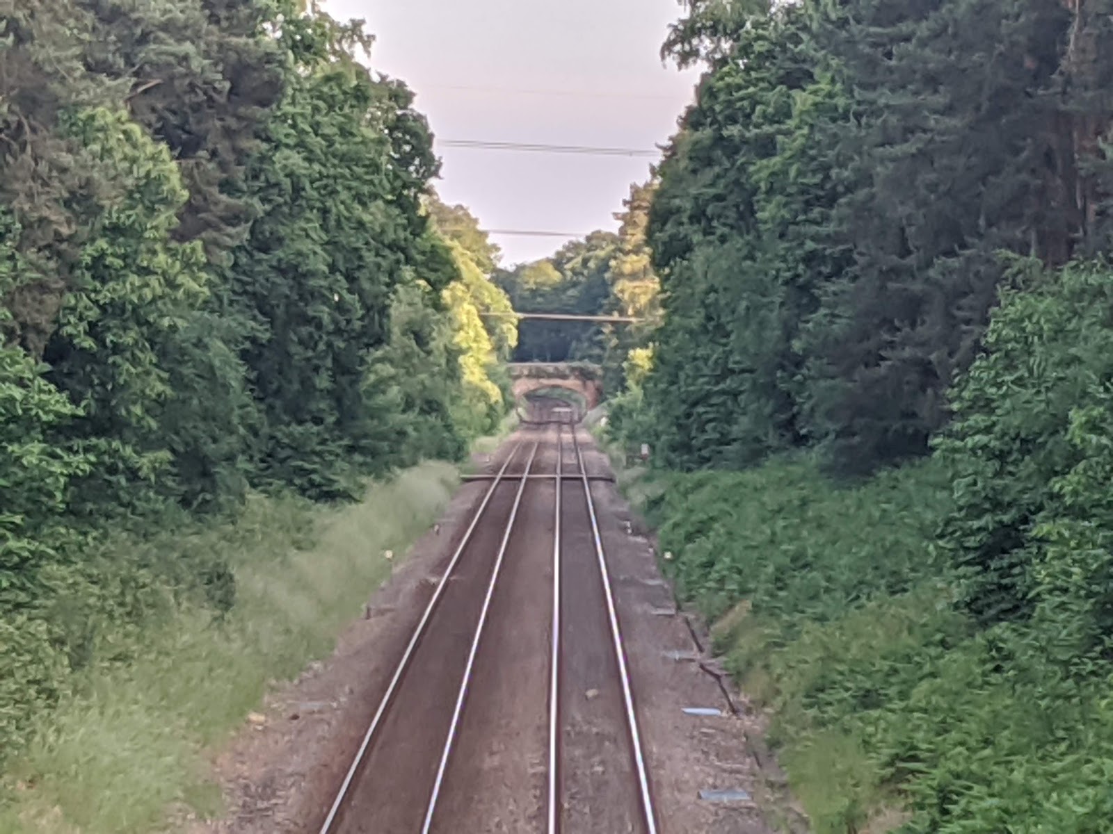
The crossing carried Sandhurst Footpath 9A across the two railway tracks on wooden boards and was protected only by iron “kissing gates” and signage warning to stop look and listen for trains. Around 80 trains pass this point each day at up to 70mph, although most will be going slower due to the closeness of Crowthorne Station. There is good visibility up and down the line in both directions.
I can’t find any record online of any incidents at the location but Network Rail seem to have a policy of seeking to close as many level crossings as they can anyway.
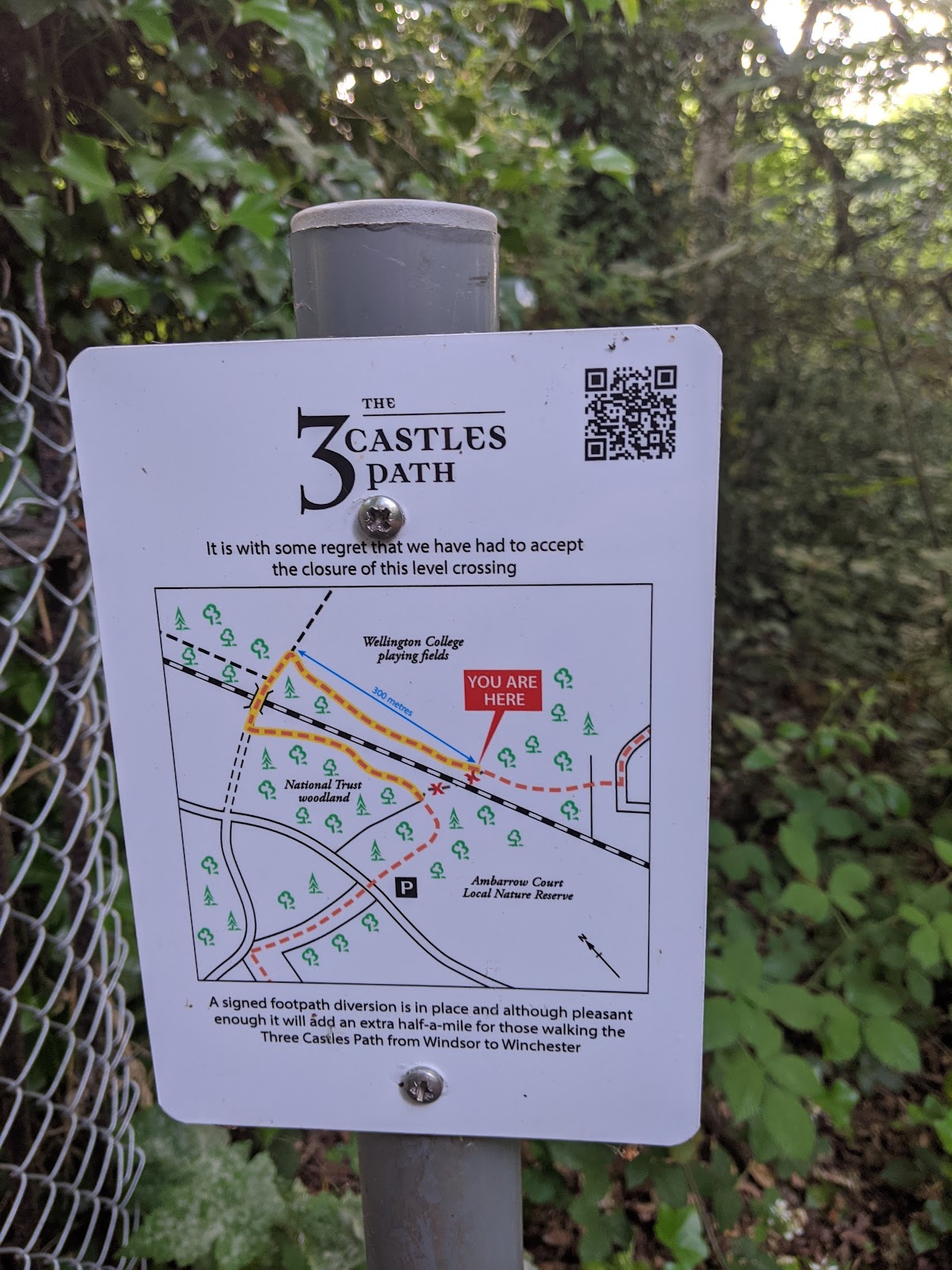
Footpath 9A and its crossing also formed part of the long distance Three Castles Path between Windsor Castle and Winchester Castle (the third being Odiham).
3 Counties Path sign
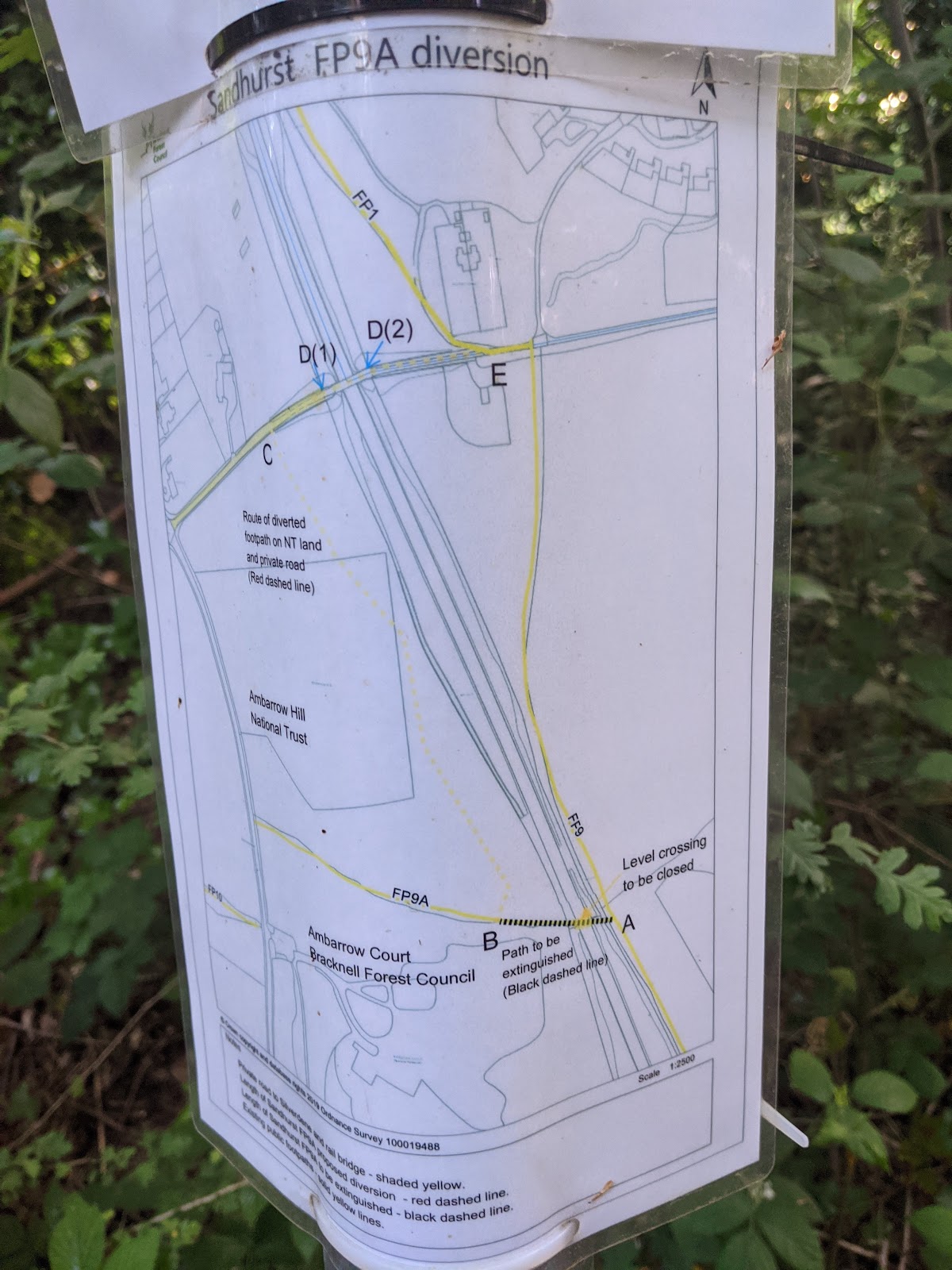
As a result this path is now half a mile longer, it being necessary to walk up one side of the line, cross over on Kiln Bridge, and walk back down the other side to regain the route. It’s not an unpleasant diversion but probably not as interesting as a pedestrian level crossing.
Harveys Crossing from Kiln Bridge
The crossing from Kiln Bridge to the north.
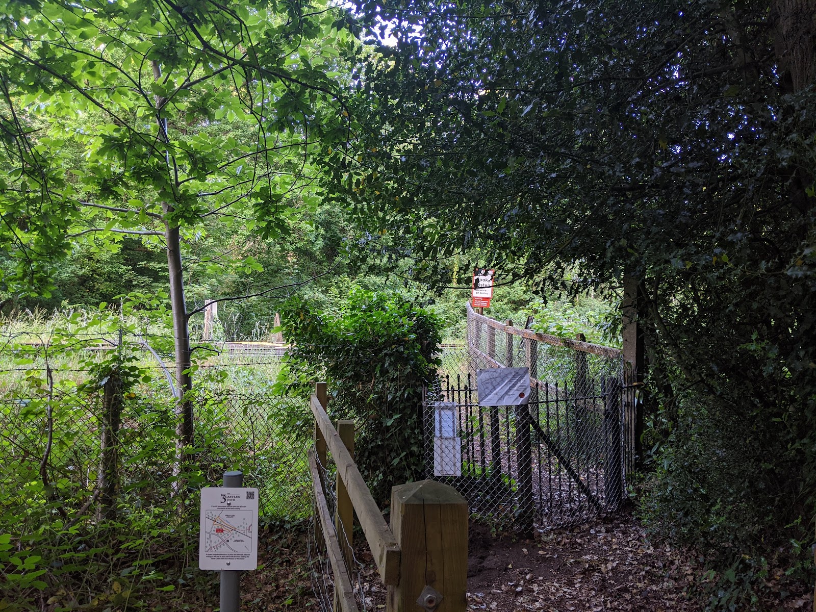
Harveys Crossing Ambarrow Court gateway
The crossing from the Ambarrow Court side.
Closure Notice
Official closure notice.
Diversion route
Footpath diversion route.
So now we no longer have a level crossing. Few will miss it I suppose. 
I wonder how long it will take the council to remove the Public Footpath fingerpost sign that still points through the chainlink fence across the railway tracks on the eastern side?